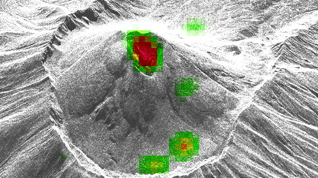

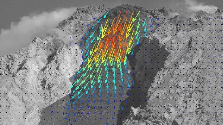
Interferometric Synthetic Aperture Radar (InSAR) and pixel offset tracking are pivotal techniques in our geospatial analysis, offering unparalleled capabilities for monitoring and understanding volcanoes and earthquakes. InSAR exploits phase differences in radar images taken at different times to measure ground deformation with millimeter precision, making it indispensable for applications such as tectonic movement, volcanic activity, and subsidence monitoring. Pixel offset tracking, on the other hand, analyzes shifts in pixel positions between radar and optical images, enabling the detection of larger displacements that InSAR may not capture effectively, such as those caused by lava domes, flows, and other mass movements.
These techniques provide comprehensive and high-resolution data over large and often inaccessible areas, significantly enhancing our ability to predict natural hazards and assess their impact. The integration of InSAR and pixel offset methods allows for a detailed and multifaceted understanding of geophysical processes, facilitating more accurate risk assessments and better-informed decision-making for disaster management and infrastructure planning. In our team, we are training and applying InSAR techniques since many years, as part of the <u>International Training Courses</u> and regular classes at the University Potsdam.
By advancing our capability to monitor the Earth's surface in near real-time, InSAR and pixel offset tracking we contribute to improved understanding of natural disasters.
In our team we have strong computing power, and processing software including GAMMA, SarScape, SarPROZ, and SNAP.
Zorn, E.U., F. Amelung, F. Massimetti, M. Laiolo, D. Coppola, T.R. Walter, Y. Lavallée, and H. Darmawan, 2025, Long-term deformation of coastal volcanoes in SE-Asia: linking displacement rates, volcanic activity and flank instabilities. Bulletin of Volcanology. 88(1). DOI: 10.1007/s00445-025-01915-z.
Auer, A., T.R. Walter, L. Ostorero, A. Belousov, M. Belousova, H. Balcone-Boissard, G. Boudon, R. Mania, and A.V. Shevchenko, 2025, Effervescent fountaining-a transition between explosive and lava-dome forming eruptions: evidence from "boiling-over" pyroclastic flows from the March 2019 eruption of Bezymianny volcano, Kamchatka. Bulletin of Volcanology. 87(10). DOI: 10.1007/S00445-025-01868-3.
Nozadkhalil, T., Z. Çakir, S. Ergintav, U. Dogan, and T.R. Walter, 2023, Land subsidence due to natural gas extraction in the Thrace basin (NW Turkey) and its influence on the North Anatolian fault under the Marmara Sea. Turkish Journal of Earth Sciences. 32(3): p. 421-430. DOI: 10.55730/1300-0985.1852.
Valade, S., Coppola, D., Campion, R. et al. Lava dome cycles reveal rise and fall of magma column at Popocatépetl volcano. Nature Commun 14, 3254 (2023). <u>https://doi.org/10.1038/s41467-023-38386-9</u>
Walter, T. R. (2023): Radar Sensing of Merapi Volcano. - In: Gertisser, R., Troll, V. R., Walter, T., Nandaka, I. G. M. A., Ratdomopurbo, A. (Eds.), Merapi Volcano: Geology, Eruptive Activity, and Monitoring of a High-Risk Volcano, (Active Volcanoes of the World), Cham : Springer International Publishing, 437-456. <u>https://doi.org/10.1007/978-3-031-15040-1_14</u>.
EU Zorn, M Vassileva, TR Walter, H Darmawan, L Röhler, F Amelung (2023) Interactions of magmatic intrusions with the multiyear flank instability at Anak Krakatau volcano, Indonesia: Insights from InSAR and analogue modeling. Geology 51 (4), 340-344. <u>https://doi.org/10.1130/G50693.1</u>.
Plank, S., A.V. Shevchenko, P. d'Angelo, V. Gstaiger, P.J. Gonzalez, S. Cesca, S. Martinis, and T.R. Walter, 2023, Combining thermal, tri-stereo optical and bi-static InSAR satellite imagery for lava volume estimates: the 2021 Cumbre Vieja eruption, La Palma. Nature Scientific Reports. 13(1). <u>https://doi.org/10.1038/s41598-023-29061-6</u>.
Walter, T.R., E.U. Zorn, C.E. Harnett, A.V. Shevchenko, A. Belousov, M. Belousova, and M.S. Vassileva, 2022, Influence of conduit and topography complexity on spine extrusion at Shiveluch volcano, Kamchatka. Nature Communications Earth & Environment. 3(1). <u>https://doi.org/10.1038/s43247-022-00491-w</u>.
Munoz, V., T.R. Walter, E.U. Zorn, A.V. Shevchenko, P.J. Gonzalez, D. Reale, and E. Sansosti, 2022, Satellite Radar and Camera Time Series Reveal Transition from Aligned to Distributed Crater Arrangement during the 2021 Eruption of Cumbre Vieja, La Palma (Spain). Remote Sensing. 14(23). <u>https://doi.org/10.3390/rs14236168</u>.
Flovenz, O.G., R.J. Wang, G.P. Hersir, T. Dahm, S. Hainzl, M. Vassileva, V. Drouin, S. Heimann, M.P. Isken, E.A. Gudnason, K. Agustsson, T. Agustsdottir, J. Horalek, M. Motagh, T.R. Walter, E. Rivalta, P. Jousset, C.M. Krawczyk, and C. Milkereit, 2022, Cyclical geothermal unrest as a precursor to Iceland's 2021 Fagradalsfjall eruption. Nature Geoscience. 15(5): 397. <u>https://doi.org/10.1038/s41561-022-00930-5</u>.
Koulakov, I., P. Plechov, R. Mania, T.R. Walter, S.Z. Smirnov, I. Abkadyrov, A. Jakovlev, V. Davydova, S. Senyukov, N. Bushenkova, A. Novgorodova, T. Stupina, and S.Y. Droznina, 2021, Anatomy of the Bezymianny volcano merely before an explosive eruption on 20.12.2017. Scientific Reports. 11(1). DOI: 10.1038/S41598-021-81498-9.
Vassileva, M., D. Al-Halbouni, M. Motagh, T.R. Walter, T. Dahm, and H.U. Wetzel, 2021, A decade-long silent ground subsidence hazard culminating in a metropolitan disaster in Maceio, Brazil. Nature Scientific Reports. 11(1). <u>https://doi.org/10.1038/s41598-021-87033-0</u>.
Shevchenko, A.V., V.N. Dvigalo, E.U. Zorn, M.S. Vassileva, F. Massimetti, T.R. Walter, I.Y. Svirid, S.A. Chirkov, A.Y. Ozerov, V.A. Tsvetkov, and I.A. Borisov, 2021, Constructive and Destructive Processes During the 2018-2019 Eruption Episode at Shiveluch Volcano, Kamchatka, Studied From Satellite and Aerial Data. Frontiers in Earth Science. 9. <u>https://doi.org/10.3389/feart.2021.680051</u>. .
Mania, R., S. Cesca, T.R. Walter, I. Koulakov, and S.L. Senyukov, 2021, Inflating Shallow Plumbing System of Bezymianny Volcano, Kamchatka, Studied by InSAR and Seismicity Data Prior to the 20 December 2017 Eruption. Frontiers in Earth Science. 9. <u>https://doi.org/10.3389/feart.2021.765668</u>.
Ghosh, B., M. Motagh, M.H. Haghighi, M.S. Vassileva, T.R. Walter, and S. Maghsudi, 2021, Automatic Detection of Volcanic Unrest Using Blind Source Separation With a Minimum Spanning Tree Based Stability Analysis. Ieee Journal of Selected Topics in Applied Earth Observations and Remote Sensing. 14: p. 7771-7787. <u>https://doi.org/10.1109/JSTARS.2021.3097895</u>.
Coppola, D., L. Marco, F. Massimetti, S. Hainzl, A.V. Shevchenko, R. Mania, M. Nikolai, Shapiro, and T.R. Walter, 2021, Thermal remote sensing reveals communication between volcanoes of the Klyuchevskoy Volcanic Group. Nature Scientific Reports. 11(1). <u>https://doi.org/10.1038/s41598-021-92542-z</u>.
Zorn, E.U., T.R. Walter, J.B. Johnson, and R. Mania, 2020, UAS-based tracking of the Santiaguito Lava Dome, Guatemala. Scientific Reports. 10(1). DOI: 10.1038/S41598-020-65386-2.
Heap, M.J., P. Baud, J.A. McBeck, F. Renard, L. Carbillet, and S.A. Hall, 2020, Imaging strain localisation in porous andesite using digital volume correlation. Journal of Volcanology and Geothermal Research. 404. DOI: 10.1016/j.jvolgeores.2020.107038.
Vassileva, M.S., M. Motagh, T.R. Walter, H.U. Wetzel, and S.L. Senyukov, 2020, The 29 March 2017 Yuzhno-Ozernovskoe Kamchatka Earthquake: Fault Activity in An Extension of the East Kamchatka Fault Zone as Constrained by InSAR Observations. Bulletin of the Seismological Society of America. 110(3): p. 1101-1114. <u>https://doi.org/10.1785/0120190174</u>.
Shevchenko, A.V., V.N. Dvigalo, T.R. Walter, R. Mania, F. Maccaferri, I.Y. Svirid, A.B. Belousov, and M.G. Belousova, 2020, The rebirth and evolution of Bezymianny volcano, Kamchatka after the 1956 sector collapse. Nature Communications Earth & Environment. 1(1). <u>https://doi.org/10.1038/s43247-020-00014-5</u>.
Gaete, A., J.L. Kavanagh, E. Rivalta, S.H. Hazim, T.R. Walter, and D.J.C. Dennis, 2019, The impact of unloading stresses on post-caldera magma intrusions. Earth and Planetary Science Letters. 508: p. 109-121. DOI: 10.1016/j.epsl.2018.12.016.
Astort, A., T.R. Walter, F. Ruiz, L. Sagripanti, A. Nacif, G. Acosta, and A. Folguera, 2019, Unrest at Domuyo Volcano, Argentina, Detected by Geophysical and Geodetic Data and Morphometric Analysis. Remote Sensing. 11(18). DOI: 10.3390/Rs11182175.
Zorn, E.U., N. Le Corvec, N.R. Varley, J.T. Salzer, T.R. Walter, C. Navarro-Ochoa, D.M. Vargas-Bracamontes, S.T. Thiele, and R.A. Mendoza, 2019, Load Stress Controls on Directional Lava Dome Growth at Volcan de Colima, Mexico. Frontiers in Earth Science. 7. DOI: 10.3389/Feart.2019.00084.
Walter, T.R., C.E. Harnett, N. Varley, D.V. Bracamontes, J. Salzer, E.U. Zorn, M. Breton, R. Arambula, and M.E. Thomas, 2019, Imaging the 2013 explosive crater excavation and new dome formation at Volcan de Colima with TerraSAR-X, time-lapse cameras and modelling. Journal of Volcanology and Geothermal Research. 369: p. 224-237. <u>https://doi.org/10.1016/j.jvolgeores.2018.11.016</u>.
Walter, T.R., M.H. Haghighi, F.M. Schneider, D. Coppola, M. Motagh, J. Saul, A. Babeyko, T. Dahm, V.R. Troll, F. Tilmann, S. Heimann, S. Valade, R. Triyono, R. Khomarudin, N. Kartadinata, M. Laiolo, F. Massimetti, and P. Gaebler, 2019, Complex hazard cascade culminating in the Anak Krakatau sector collapse. Nature Communications. 10. <u>https://doi.org/10.1038/s41467-019-12284-5</u>.
Valade, S., A. Ley, F. Massimetti, O. D'Hondt, M. Laiolo, D. Coppola, D. Loibl, O. Hellwich, and T.R. Walter, 2019, Towards Global Volcano Monitoring Using Multisensor Sentinel Missions and Artificial Intelligence: The MOUNTS Monitoring System. Remote Sensing. 11(13). <u>https://doi.org/10.3390/rs11131528</u>.
Plank, S., T.R. Walter, S. Martinis, and S. Cesca, 2019, Growth and collapse of a littoral lava dome during the 2018/19 eruption of Kadovar Volcano, Papua New Guinea, analyzed by multi-sensor satellite imagery. Journal of Volcanology and Geothermal Research. 388. <u>https://doi.org/10.1016/j.jvolgeores.2019.106704</u>.
Mania, R., T.R. Walter, M. Belousova, A. Belousov, and S.L. Senyukov, 2019, Deformations and Morphology Changes Associated with the 2016-2017 Eruption Sequence at Bezymianny Volcano, Kamchatka. Remote Sensing. 11(11). <u>https://doi.org/10.3390/rs11111278</u>.
Diao, F.Q., X. Xiong, R.J. Wang, T.R. Walter, Y.B. Wang, and K. Wang, 2019, Slip Rate Variation Along the Kunlun Fault (Tibet): Results From New GPS Observations and a Viscoelastic Earthquake-Cycle Deformation Model. Geophysical Research Letters. 46(5): p. 2524-2533. <u>https://doi.org/10.1029/2019GL081940</u>.
Witt, T., T.R. Walter, D. Muller, M.T. Gudmundsson, and A. Schopa, 2018, The Relationship Between Lava Fountaining and Vent Morphology for the 2014-2015 Holuhraun Eruption, Iceland, Analyzed by Video Monitoring and Topographic Mapping. Frontiers in Earth Science. 6. DOI: 10.3389/Feart.2018.00235.
Richter, N., J.T. Salzer, E. de Zeeuw-van Dalfsen, D. Perissin, and T.R. Walter, 2018, Constraints on the geomorphological evolution of the nested summit craters of Lascar volcano from high spatio-temporal resolution TerraSAR-X interferometry. Bulletin of Volcanology. 80(3). <u>https://doi.org/10.1007/s00445-018-1195-3</u>.
Bredemeyer, S., F.G. Ulmer, T.H. Hansteen, and T.R. Walter, 2018, Radar Path Delay Effects in Volcanic Gas Plumes: The Case of Lascar Volcano, Northern Chile. Remote Sensing. 10(10). <u>https://doi.org/10.3390/rs10101514</u>.
Holohan, E.P., H. Sudhaus, T.R. Walter, M.P.J. Schopfer, and J.J. Walsh, 2017, Effects of Host-rock Fracturing on Elastic-deformation Source Models of Volcano Deflation. Scientific Reports. 7. DOI: 10.1038/S41598-017-10009-6.
Nikkhoo, M., T.R. Walter, P.R. Lundgren, and P. Prats-Iraola, 2017, Compound dislocation models (CDMs) for volcano deformation analyses. Geophysical Journal International. 208(2): p. 877-894. DOI: 10.1093/gji/ggw427.
Salzer, J.T., P. Milillo, N. Varley, D. Perissin, M. Pantaleo, and T.R. Walter, 2017, Evaluating links between deformation, topography and surface temperature at volcanic domes: Results from a multi-sensor study at Volcan de Colima, Mexico. Earth and Planetary Science Letters. 479: p. 354-365. <u>https://doi.org/10.1016/j.epsl.2017.09.027</u>.
Zhang Y, Wang R, Walter TR, Feng W, Chen Y, Huang Q (2017) Significant Lateral Dip Changes May Have Limited the Scale of the 2015 Mw7.8 Gorkha Earthquake. Geophys. Res. Lett., <u>https://doi.org/10.1002/2017GL074095</u>.
Richter, N., M. Favalli, E. de Zeeuw-van Dalfsen, A. Fornaciai, R.M.D. Fernandes, N.M. Perez, J. Levy, S.S. Victoria, and T.R. Walter, 2016, Lava flow hazard at Fogo Volcano, Cabo Verde, before and after the 2014-2015 eruption. Natural Hazards and Earth System Sciences. 16(8): p. 1925-1951. DOI: 10.5194/nhess-16-1925-2016.
Diao, F.Q., T.R. Walter, F. Minati, R.J. Wang, M. Costantini, S. Ergintav, X. Xiong, and P. Prats-Iraola, 2016, Secondary Fault Activity of the North Anatolian Fault near Avcilar, Southwest of Istanbul: Evidence from SAR Interferometry Observations. Remote Sensing. 8(10). DOI: 10.3390/Rs8100846.
Nikolaeva, E., Walter, T. R. (2016): InSAR observations of the 2009 Racha earthquake, Georgia. - Natural Hazards and Earth System Sciences (NHESS), 16, p. 2137-2144. <u>http://doi.org/10.5194/nhess-16-2137-2016</u>.
Salzer, J. T., Thelen, W. A., James, M. R., Walter, T. R., Moran, S., Denlinger, R. (2016): Volcano dome dynamics at Mount St. Helens: Deformation and intermittent subsidence monitored by seismicity and camera imagery pixel offsets. - Journal of Geophysical Research, 121, 11, p. 7882-7902, <u>http://doi.org/10.1002/2016JB013045</u>.
F Diao, F.Q., T.R. Walter, G. Solaro, R.J. Wang, M. Bonano, M. Manzo, S. Ergintav, Y. Zheng, X. Xiong, and R. Lanari, Fault locking near Istanbul: indication of earthquake potential from InSAR and GPS observations. Geophysical Journal International, 2016. 205(1): p. 490-498. <u>https://doi.org/10.1093/gji/ggw048</u>.
Prats-Iraola P, Nannini M, Scheiber R, De Zan F, Wollstadt S, Minati F, Vecchioli F, Costantini M, Borgstrom S, De Martino P, Siniscalchi V, Walter TR, Foumelis M, Desnos Y-L (2015) Sentinel-1 assessment of the interferometric wide-swath mode. IEEE International, <u>https://doi.org/10.1109/IGARSS.2015.7327018</u>.
H Bathke, M Nikkhoo, E P Holohan, TR Walter (2015) Insights into the 3D architecture of an active caldera ring-fault atTendürek volcano through modeling of geodetic data. Earth and Planetary Science Letters 422, 157–168. <u>https://doi.org/10.1016/j.epsl.2015.03.041</u>.
TR Walter, Subandriyo J, Kirbani S, Bathke H, Suryanto W, Aisyah N, Darmawan H, Jousset P, Lühr BG, Dahm T (2015) Volcano-tectonic control of Merapi’s lava dome splitting: The November 2013 fracture observed from high resolution TerraSAR-X data. Tectonophysics 639, 23–33. <u>https://doi.org/10.1016/j.tecto.2014.11.007</u>.
JT Salzer, M Nikkhoo, TR Walter, H Sudhaus, G Reyes-Dávila, M Bretón, R. Arambula (2014) Satellite radar data reveal short-term pre-explosive displacements and a complex conduit system at Volcán de Colima, Mexico. Front. Earth Sci., 27 June 2014 | <u>https://doi.org/10.3389/feart.2014.00012</u>.
TR Walter, M Shirzaei, A Manconi, G Solaro, A Pepe, M Manzo, E Sansosti (2014) Possible coupling of Campi Flegrei and Vesuvius as revealed by InSAR time series, correlation analysis and time dependent modeling. Journal of Volcanology and Geothermal Research 280, 1, 104–110. <u>https://doi.org/10.1016/j.jvolgeores.2014.05.006</u>.
Walter TR, Motagh M (2014) Deflation and inflation of a large magma body beneath Uturuncu volcano, Bolivia? Insights from InSAR data, surface lineaments and stress modelling. Geophys. J. Int. 198 (1), 462-473. <u>https://doi.org/10.1093/gji/ggu080</u>.
(for publications older than this please refer to the <u>GFZ section 2.1 publication page</u>)