Automatic near real-time determination of co-seismic displacements (Ground Tracking System) | GTS

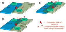
The magnitude and location (epicenter and depth) of a strong earthquake can be determined quickly and accurately using seismological methods and technology. Seismology also allows an estimation, but until now, not an accurate determination of possible movements (deformations) of the Earth’s surface in the earthquake’s area. However, knowledge of these co-seismic deformations is particularly relevant for an early warning system to quickly answer the question of whether an earthquake has triggered a tsunami. Help comes from GNSS-instrumentation (GNSS-stations) and a special analysis system which detects and precisely determines ground motions on the Earth’s surface. The GNSS-based determination of ground movements works particularly well near the epicenter, where the magnitude of the ground movements is high. By contrast, seismological sensors near the epicenter can be overloaded, while measurements from sensors further away may only be available after a certain time due to the travel time of the seismic signals. In combination with other techniques (determination of the tsunami-inducing mechanism and the rupture area), the reliability of tsunami early warnings can be significantly improved by using GNSS-based ground motion measurements (Figure 1).

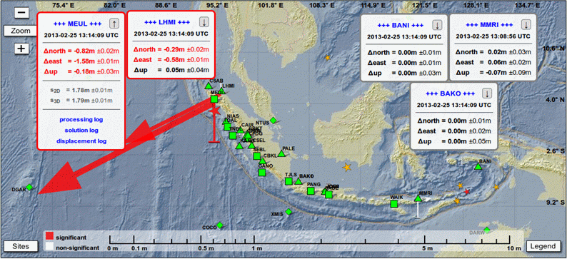
A system for an automatic determination of ground motions, respectively co-seismic deformations, was developed by GFZ within the project GITEWS. It is supported by an automatic GNSS processing system for near real-time processing of data continuously measured from GNSS-stations in and around Indonesia. This system, which has been implemented at the Indonesian warning centre as a ground tracking system, is capable of providing initial values (3D displacement vectors) for relevant, i.e. particularly earthquake-prone, locations with GNSS instruments within three minutes of a strong earthquake. These initial values are then updated every two minutes (Figure 2).
Precise information on possible ground movements is also provided for the locations of tide gauge stations, provided that they are equipped with GNSS devices. If the location of a tide gauge station has changed, for example due to an earthquake, the water levels measured there must be corrected or discarded for early warning purposes.
Project partners:
- BMKG (Meteorology, Climatology and Geophysics Agency, Jakarta, Indonesia)
Time frame:
- 2005 -2011
Funding:
- German Federal Ministry for Education and Research (BMBF), Grant 03TSU01
Project related publication:
- Falck, C., Ramatschi, M., Subarya, C., Bartsch, M., Merx, A., Hoeberechts, J., Schmidt, G. (2010): Near real-time GPS applications for tsunami early warning systems. - Natural Hazards and Earth System Sciences (NHESS), 10, 2, 181-189. https://doi.org/10.5194/nhess-10-181-2010