Global Land Monitoring (GLM)
The Global Land Monitoring (GLM) group develops and applies innovative methodological approaches to improve systematic, large-scale monitoring of land dynamics worldwide. Our work bridges near-sensing and satellite-based Earth observation, focusing on time-series analysis and multi-sensor data integration through data science and big data analytics.
We actively contribute to global calibration and validation networks to ensure the accuracy and reliability of remote sensing–derived land data and products across a range of environmental applications. A core emphasis of our research lies in the use of advanced LiDAR and hyperspectral technologies to better capture the complex three-dimensional and biogeochemical characteristics of land surfaces and vegetation structure.
Our efforts are grounded in a global monitoring perspective and a strong commitment to national and international collaboration.
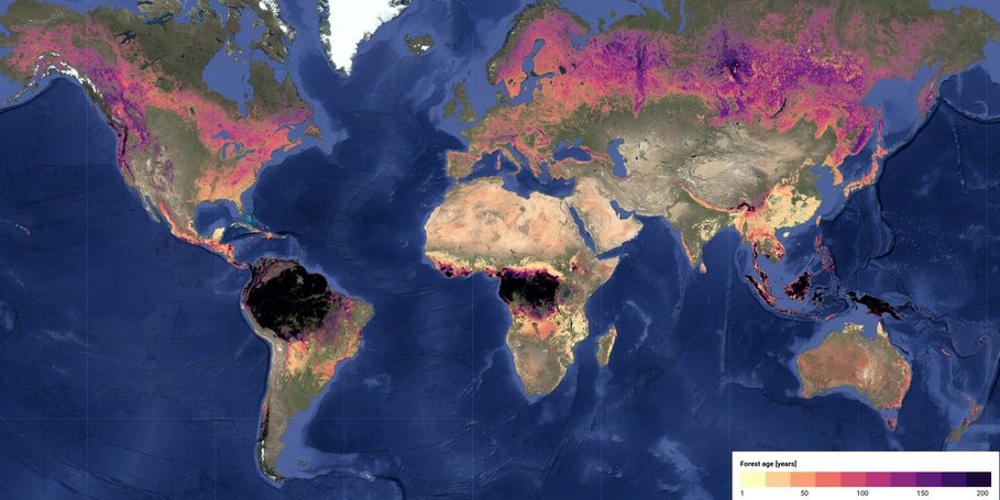
The biosphere plays a critical role in regulating Earth's carbon balance, water availability, and nutrient cycle of the Earth system. To monitor and understand these dynamics at scale, we rely on Earth Observation (EO): consistent, repeated satellite measurements that reveal environmental change over time. Our focus on large-scale EO enables us to track biosphere processes across regional to global extents, with particular attention to forests and their structural, functional, and land-use dynamics.
Building on Section 1.4 methodological focus, the LEO subgroup develops data-driven methods to integrate large-scale EO with ecological and carbon cycle science. We focus on understanding forest dynamics, including structural changes and land-use transitions, and how they affect and are affected by the carbon cycle. For this, we integrate various EO products at different scales and incorporate ground data such as National Forest Inventories.
Research Areas
- Forest Land Use and Land Cover Dynamics: We explore how to build robust maps of forest land use using EO and machine learning, and how regrowth patterns vary across land-use systems, including secondary, primary, and plantation forests.
- Vertical Structure and Forest Dynamics: We study how vertical forest structure, observed via spaceborne lidar like GEDI, influences biodiversity and carbon cycling. We also examine structural changes before and after disturbance and advance signal processing techniques for 3D forest mapping.
- Carbon Emissions and Policy Implications: We work on attributing deforestation-related carbon emissions to commodity supply chains, supporting policies like the EU Deforestation Regulation (EUDR). We also compare forest carbon flux estimates from global products and national datasets.
- Energy Efficiency of Data Analytics Workflows: We aim to optimise EO data workflows for scalability and energy efficiency, assess the environmental footprint of large-scale analytics, and explore trade-offs in computing strategies.
Projects
- EC FORWARDS (2023-2027): website
- EC OpenEarthMonitor (2022-2026): https://earthmonitor.org
- EC ForestNavigator (2022-2025): http://www.forestnavigator.eu
- ESA ForestCarbon (2022-2023): https://www.forestcarbonplatform.org
- EC NextGen2Carbon (2025-2029): Home | NextGenCarbon
- ESA AI4FLUM (2024-2025): Artificial Intelligence for Forest Land Use Mapping (collaboration with EC JRC and FAO).
- FONDA phase II (2024-2028): https://fonda.hu-berlin.de/
- HYPER-AMPLIFAI (2024-2027): helmholtz-imaging.de/project/hyper-amplifai/
- 3D-ABC (2024-202?): hfmi.helmholtz.de/pilot-projects/3d-abc/
- ESA CCI-Biomass (2022-26): website
Integrating measurements of changing land surfaces aims to enhance the physical underpinnings and fundamental abilities to measure how and why land surfaces are changing. The availability of data from near-sensing (UAVs) and from new satellite sensors (i.e. ENMAP, CHIME, GEDI) now allows for a full exploration of the spectral and 3D dimension for the purpose integrated large-area monitoring. Long-term, global in-situ networks of spectral and structural vegetation measurements, and the integration of active sensors and the third dimension (i.e. from RADAR and LIDAR) are essential for such a comprehensive assessment of land characteristics and changing land surfaces that will complement current global optical remote sensing approaches building on simple vegetation indices and a broad set of global land cover classes only.
In this context, our in-situ and proximal sensing activities develop and use a range of sensing techniques like terrestrial and UAV-borne laser scanning, UAV-borne hyperspectral sensing and automated monitoring technology (e.g. IoT). These data streams are used to produce high quality reference data at local scale across networks of sites to represent large areas and multiple environmental conditions for the calibration and validation of EO data. Furthermore, we take a role in coordination of international networks.
Projects
- EC NextGenCarbon (2025-2029): Home | NextGenCarbon
- ESA IDEAS-QA4EO2 (2024-2026)
- ESA Forest Digital Twin Component - Forest DTC (2024-2025) (https://www.foresttwin.org/)
- EC RemoTrees (2024 - 2028) (https://www.remotrees.eu/)
- EC FORWARDS (2023-2027): website
- StrucNet (https://www.strucnet.org)
- VODnet (https://vodnet.org - under construction)
- GEOTREES (https://data.geo-trees.org/)
In order to support effective climate action, land monitoring, and the implementation of environmental policies, targeted efforts for ensuring the adequacy of Earth Observation applications are needed. The Policy subgroup aims to bridge EO innovations with real-world needs by interacting with different scientific, policy and end-user communities. Our work is embedded in supporting climate-related land use monitoring, especially in the context of the Sustainable Development Goals (SDGs), United Nations Framework Convention on Climate Change (UNFCCC), and the European Union Deforestation Regulation (EUDR). We also play a role in international coordination efforts, including the Global Forest Observations Initiative (GFOI) R&D Component, which is coordinated within this subgroup.
We are also actively involved in the development and review of policy frameworks, co-design of EO products, and integration of satellite and in-situ data to provide clear, reproducible, and locally relevant insights. For example, we work to address technical and methodological challenges that hinder progress in tropical countries’ forest monitoring and GHG inventory systems. Members of our team contribute to global science-policy processes as authors of IPCC reports and contributors to Good Practice Guidelines, helping translate cutting-edge land and carbon monitoring science into actionable policy information. We bring together expertise in EO and National Forest Inventory (NFI) integration, land cover change monitoring, and the estimation of forest carbon emissions and removals, with the broader purpose of enhancing environmental policy implementation at local to global scales.


