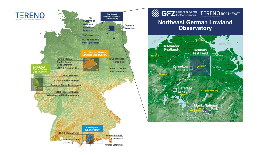
The Northeastern German Lowland observatory (TERENO-Northeast) is part of the Helmholtz Association`s interdisciplinary, long-term research network of Terrestrial Environmental Observatories - TERENO representing typical landscapes in Central Europe. TERENO-Northeast represents typical northeastern German lowland landscape, including both near-natural areas like Müritz National Park and regions that are intensively influenced and managed by human activities like farming.
Northeastern Germany, where the GFZ-run observatory TERENO-Northeast is situated, is one of the regions in Germany most vulnerable to global change. The main research foci are to understand the regional impact of global change on the Earth’s surface and near-subsurface (landscape evolution, hydrology and carbon budget) and, in turn, the influence of the Earth’s surface on atmosphere and climate via greenhouse gas fluxes. Current observations through extensive monitoring are linked with long-term proxy time series based on paleoclimate archives such as lake sediments and tree ring chronologies. This allows us to evaluate recent trends in the context of long-term temporal variability of the systems at hand. Investigations of long time series of climate change and landscape evolution are based on the hypothesis that observed recent trends can be reliably evaluated only in the context of profound knowledge of long‐term trends and their underlying processes.
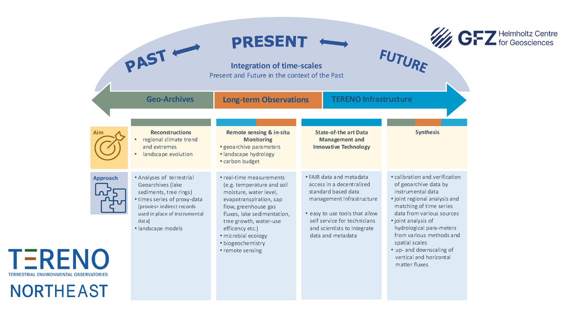
The complex relationships and feedback mechanisms of the different parts of the terrestrial systems require an interdisciplinary research approach. Important system variables, which are being monitored within TERENO, include: relocation and exchange processes of water, matter and energy in the groundwater-vegetation-atmosphere system, long-term changes in the structure and functioning of microorganisms, flora and fauna, as well as socioeconomic conditions that must be determined with sufficient temporal and spatial resolution.
We are tackling the following scientific questions:
- Which consequences will the expected climate change have on the groundwater, soils, vegetation and surface waters?
- In which way will the feedbacks mechanisms affect the terrestrial fluxes of water and matter (e.g. feedbacks between land surface and atmosphere)?
- Which direct influences have soil and landuse changes on water balance, soil fertility, biodiversity and regional climate?
- What are the consequences of large anthropogenic interferences (e.g. open mining, deforestation) on terrestrial systems?
The long-term data sets developed in TERENO will significantly foster the validation, advancement and integration of terrestrial models, e.g. groundwater and soil water balance models, regional climate and weather prognostic models, air quality models, runoff and forest/agronomic models as well as diversity and socioeconomical models. Integrated model systems can comprehensively support the management of agronomic and forest ecosystems, e.g. optimization of irrigation systems as well as development of warning systems for extreme weather occurrences and flooding, integrated control systems of water management constructions, and monitoring systems for air, groundwater and surface water quality.
Data Management

All TERENO-Northeast data can be accessed via the Data Discovery Portal. Further information can be found at www.TERENO.net.
Earth–Atmosphere-Interactions

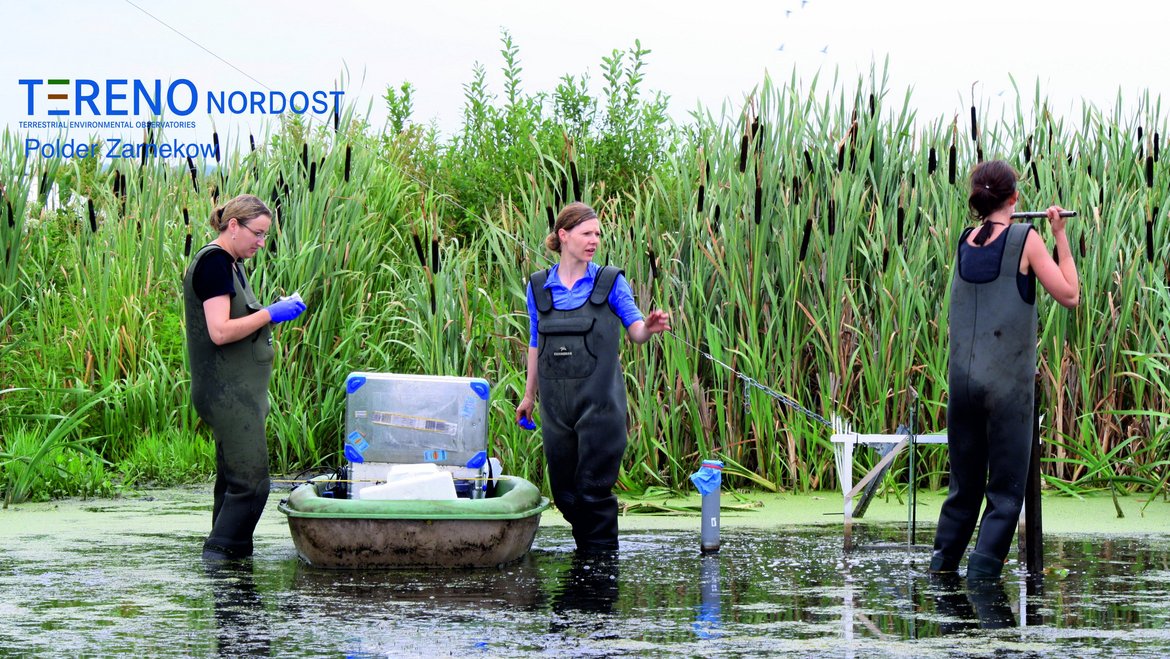
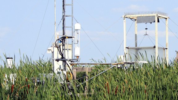
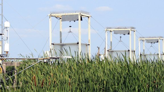
We investigate processes and drivers underlying (changes in) the geosphere-atmosphere exchange of heat, water vapor, and carbon on a range of temporal (hourly to multi-annual) and spatial (TERENO Northeast: local to regional) scales. The aim is to improve the understanding of the biological, chemical and physical processes that control the exchange of energy and greenhouse gases between soil, vegetation and atmosphere. We are combining ground-based and airborne micro-meteorological measurements, biogeochemical analyses, airborne and satellite remote sensing, numerical simulations, and machine learning methods. The current focus is on heavily disturbed and very dynamic peatland systems in NE Germany rewetted peat bog of the Peene near Zarnekow / Dargun. By determining the gas fluxes between the ecosystem and the atmosphere using the so-called eddy covariance method, we aim to quantify changes in atmospheric composition and radiative forcing resulting from Earth surface processes. The eddy covariance gas exchange determination method is used at eddy-towers, as well as by means of helicopter or aircraft rides, in order to examine areas of different sizes.
Contact: Prof. Torsten Sachs
Remote Sensing

In the DEMMIN test field data on vegetation, soil and exchange processes between soil and atmosphere are recorded. The terrestrial data are compared with aircraft and satellite-based information from remote sensing. These algorithms can finally be transferred to areas for which there are remote sensing data, but only a few terrestrial data available. This facilitates to efficiently gain regional insights into environmental conditions.
Contact: Dr. Sibylle Itzerott
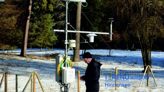
Hydrology

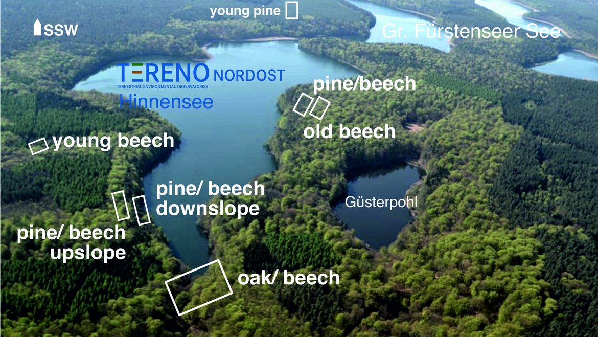
In the Great Lake Fürstensee and in its catchment area (Müritz National Park), the dynamics of water and matter moving between running water, sediment and groundwater are examined in detail. In addition, measuring stations are operated at various water gauges in order to monitor the water quality over an extended period of time. In summary, the landscape water balance in the region can be comprehensively stated.
Contact: Dr. Theresa Blume
Microbial Carbon Cycling: Processes, Trace Gas Fluxes, and Paleoenvironmental Proxies

Within TERENO Northeast, the Microbial Carbon Cycling research group focuses on microbial-mediated carbon turnover and greenhouse gas dynamics in rewetted peatlands. Using molecular techniques, the group identifies, quantifies, and characterizes key microbial taxa involved in methane production and oxidation across various peatland types, assessing their activity and ecological function. This research enhances process-level understanding of trace gas fluxes, providing insights into the microbial contributions to carbon cycling under both natural and anthropogenic peatland development.
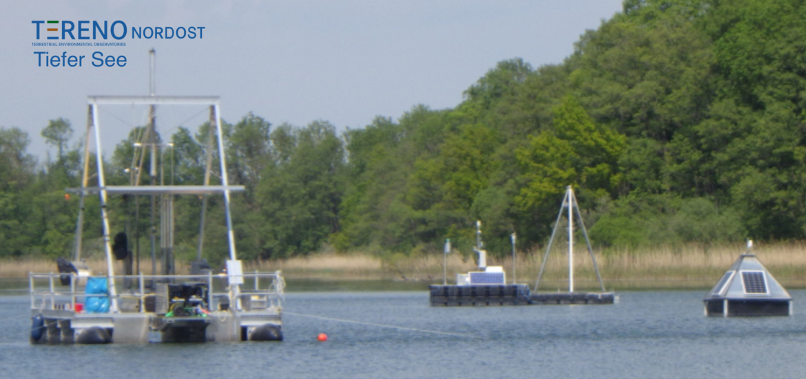
Additionally, the group investigates environmental DNA (eDNA) from lake sediments as a proxy for reconstructing Holocene lake ecosystem dynamics. Study sites include near-natural oligo- and mesotrophic kettle bogs in Müritz National Park, the Hütelmoor coastal peatland, the eutrophic Zarnekow polder, and laminated sediments of Lake Tiefer See. These diverse environments offer a comprehensive perspective on microbial community shifts, biogeochemical processes, and long-term ecosystem evolution.
Contact: Prof. Susanne Liebner
Terrestrial Climate Archives: Transfer of Environmental and Climate Signals into Lake Sediments and Tree Rings

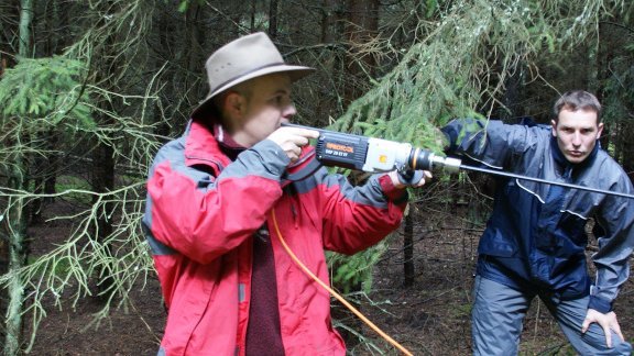
Complex instrumental data and observations on climate variability and landscape development are collected to understand and better quantify the transfer of environmental and climate signals into annually laminated lake sediments and tree rings. Instrumental observations and time series help to transfer the physical and chemical parameters measured into proxy data (proxies = substitutes for direct observations) from terrestrial archives. In addition to studying young and old living trees historical, archaeological and fossil wood material from nearby locations is investigated in cooperation with the Department of Natural Sciences at the German Archaeological Institute (DAI) in Berlin.
Contact: Dr. Gerhard Helle (Dendroclimatology and -ecology, Terrestrial Climate Archives Group, Section 4.6)
Contact: Dr. Birgit Schröder (Lake sediments and Climate reconstructions, Terrestrial Climate Archives Group, Section 4.6)
WETSCAPES2.0: Sinks, links and legacies of novel ecosystems in rewetted fen landscapes (Feb-12 2025)
The rewetted fen “Polder Zarnekow,” a key site within TERENO-Northeastern Germany, is one of the core research locations of the DFG-Transregio-Sonderforschungsbereich 410 WETSCAPES2.0. During its funding period from 2025 to 2028, WETSCAPES2.0 aims to develop an advanced functional understanding of rewetted temperate peatlands and to investigate the spatiotemporal implications of peatland rewetting at the landscape scale and beyond. The research activities at GFZ are led by Torsten Sachs and Susanne Liebner.
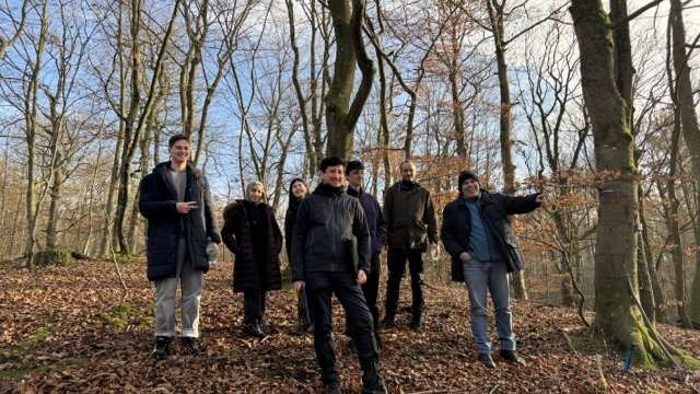
Franco-German joint field campaign at Lake Hinnensee (Nov-28 2024)
During the week of November 25-28, 2024, the TERENO-Northeast team, together with Ingo Heinrich, German Archaeological Institute (DAI), and the French team led by Jonathan Barichivich, conducted a field campaign for sampling oaks and pines at Lake Hinnensee.
Jonathan Barichivich is a Research Professor (Directeur de Recherche) at the Centre National de la Recherche Scientifique (CNRS). He is based at the Laboratoire des Sciences du Climat et de l’Environnement (LSCE) in Paris, France. He leads the ERC project CATES – Long-term Consequences of Altered Tree Growth and Physiology in the Earth System. The project’s goal is to improve the ecology of the terrestrial component of the IPSL Earth System Model using tree rings.
Jonathan’s research team is distributed across various locations in France (LSCE), the United Kingdom (CRU and the University of Leeds), and South America (Austral University of Chile, University of Chile, and Pontifical Catholic University of Valparaíso). Together with the TERENO team at GFZ, they utilize the TERENO infrastructure at Lake Hinnensee to address pressing global change questions using a broad range of direct and indirect observations, as well as models.
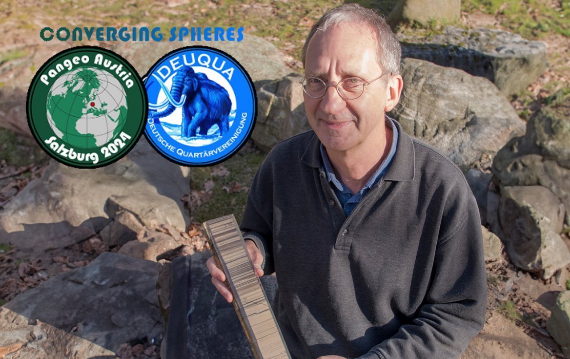
Prof. Achim Brauer honored with DEUQUA Medal of Merit (Oct-10 2024)
On 25 September 2024, Prof. Dr Achim Brauer was awarded the DEUQUA Medal of Merit. The German Quaternary Association honoured Brauer's outstanding scientific achievements in Quaternary research with its highest award. Quaternary, the most recent period in Earth’s history, began around 2.6 million years ago and extends to the present day. DEUQUA e.V. is the association of German-speaking Quaternary scientists. The award was presented during the joint international annual conference of the Austrian Geological Society (AGS) and DEUQUA, “Pangeo-DEUQUA 2024” in Salzburg.
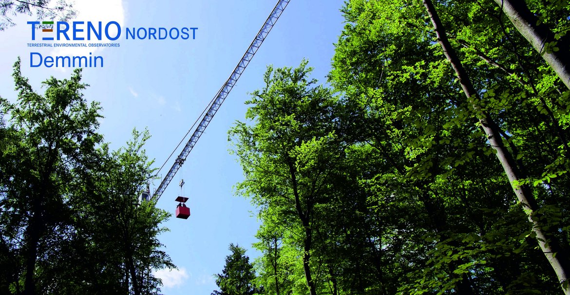
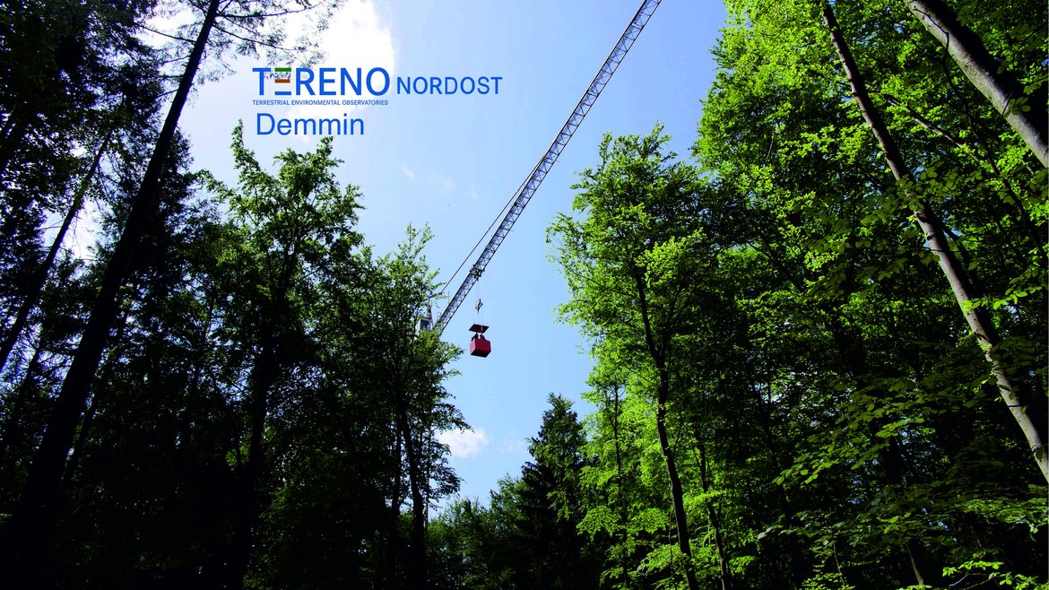
Exploring Tree Crowns by Crane (May-17 2023)
How can the health status of different tree species in mixed forests be better identified with the help of aerial and satellite images? Is this even possible in time to intervene? A 45-meter-high construction crane located in the middle of a mixed forest in Mecklenburg-Western Pomerania is helping to answer these questions. The crane hoists people and measuring equipment above the treetops to obtain comparative data. The aim is to improve forest monitoring.
The crane is part of a cross-state research network that has been funded by the Agency for Renewable Resources (FNR) since the end of 2022. In the research project called FeMoPhys, the Brandenburg State Forestry Office (LFB), the Mecklenburg-Western Pomerania State Forestry Office, the German Research Center for Geosciences (GFZ), the LUP company from Potsdam, the University of Greifswald and the Technical University of Berlin are working together.
The test site is located near the town of Demmin in Mecklenburg-Western Pomerania. Each individual crown of the different tree species - beech, oak, spruce, larch, Douglas fir - can be reached in any position via a personnel conveyor cage on the crane boom. Researchers then measure a variety of parameters at airy heights, the contents of needles and leaves, such as proteins, phenols, tannins, chlorophyll and carotenoids, the density of the crowns and the leaf water content, as well as photosynthesis parameters such as transpiration and assimilation rates. In addition, meteorological measurements, soil moisture and sap flow will be used to record water turnover in the ecosystem. In this way, the researchers want to clarify a question, which has been open since the emergence of remote sensing methods, i.e. whether physiological processes internal to trees can be detected at all via external physical sensors of spectral on-site and remote sensing.
Mecklenburg-Western Pomerania's Minister for Climate Protection, Agriculture, Rural Areas and Environment, Till Backhaus, and Brandenburg's Minister for Agriculture, Environment and Climate Protection, Axel Vogel, have now informed themselves about the research work directly at the crane site. Vogel said: "The long-standing results of the forest condition survey can now be supplemented by modern remote sensing methods. The findings here are also transferable to other federal states." Till Backhaus added: "In times of climate change, scientifically sound findings on the development of our forests are of central importance. Especially here at the site, it becomes clear that science is not an end in itself, but brings great benefits to society."
The importance of the project was also underlined by Benedikt Wilhelm from the Agency for Renewable Resources (FNR): "This project is particularly valuable because methods for monitoring the vitality development of mixed forests are being advanced here." The FNR is supporting the project with funding from the German Federal Ministry of Food and Agriculture and the German Federal Ministry for the Environment, Nature Conservation, Nuclear Safety and Consumer Protection. GFZ project manager Sibylle Itzerott said the project “has ambitious scientific goals and is an excellent example of close cooperation between research institutions and the relevant departments of the German states of Mecklenburg-Western Pomerania and Brandenburg, as well as the FNR.”
- More information:
Project website: FeMoPhys - Development of a remote sensing-based monitoring procedure based on a physiologically founded vitality assessment of main tree species in mixed stands
_____________________________________________________
Members of the Association of German Engineers (VDI) Visit GFZ Outreach Project “Climate Change on Your Doorstep”
by Gerhard Helle (Sep 11, 2025)
On September 11, 2025, members of the Association of German Engineers (VDI), Bodensee District, visited the GFZ German Research Centre for Geosciences in Potsdam to learn more about the project “Climate Change on Your Doorstep”. The monitoring setup at the Albert Einstein Campus on Potsdam’s Telegrafenberg is modeled after the forest hydrology monitoring of the TERENO Northeast network in Müritz National Park and symbolically brings it to the “doorstep” of around 3.6 million residents in the Berlin/Potsdam region. The aim is to make climate change tangible, promote environmental education, and test innovative sensing technologies—such as seismometers and fiber optics—in practical application. The VDI members took the opportunity to tour the research station, guided by Dr. Helle (Section 4.6) and Markus Morgner (4.1), and to discuss the technological, scientific and societal goals of the project.
_____________________________________________________
New Zealand Ambassador visits GFZ and explores outreach project “Climate Change on Our Doorstep”
By Gerhard Helle (Oct-25 2024)
On the occasion of his visit to the GFZ (October 21, 2024), the Ambassador of New Zealand, His Excellency Craig Hawke, together with New Zealand–Germany Science Coordinator Regina Eisert and Policy Advisor Natalie Hallensleben, took a tour of the Albert Einstein Campus at Telegrafenberg to learn about the forest hydrology outreach project “Climate Change on Your Doorstep.” The project operates a small forest eco-hydrological monitoring site that serves to demonstrate the TERENO forest-ecological monitoring network of the Helmholtz Association. It records and analyses the transfer of climate and environmental signals from the atmosphere and soil into tree-rings, allowing these to be used as high-quality terrestrial climate archives. In addition, TERENO data are used to assess tree vitality and forest health under current climate change conditions. In New Zealand, similar studies are being conducted to assess the vitality of the endemic and endangered kauri trees, which can live for more than 2,000 years. In combination with tree-ring records from fossil swamp-kauri, this species provides a climate archive spanning the past 60,000 years.
_____________________________________________________
Forest Hydrology Outreach project “Climate change on your Doorstep”
by Theresa Blume, Sibylle Itzerott, Manuela Lange, Ulrike Sylla and Gerhard Helle (Aug-08 2024)
Together with the student laboratory and the Department of Knowledge Transfer and Innovation, the TERENO team has set up a forest hydrological monitoring station in the Albert Einstein Science Park on Potsdam’s Telegrafenberg in summer 2024. For a project called “Climate change on your Doorstep” we have instrumented 3 major tree species (oak, beech, pine) with sapflow sensors and dendrometers, complemented by soil moisture sensors in different soil depths to determine water storage dynamics. In addition, wood increment cores were taken from the trees for determining the exact age of the trees and dendro-ecological analyses. Further, remote sensing data and historic photographs are collated and analyzed to reconstruct forest changes and dynamics on the historic Telegrafenberg site with its mix of young and old (up 220yrs) trees.
The instrumental setup replicates and showcases our TERENO-Northeast forest hydrological monitoring network from the Müritz National Park, bringing it to the “doorstep” of the ca. 3.6 million residents in the Berlin/Potsdam area. The initiative aims to strengthen climate change communication and foster environmental learning in close collaboration with GFZ’s school laboratory and knowledge transfer department. The established monitoring infrastructure furthermore provides opportunity for proof-of-concept testing of sensing technologies not originally used for forest monitoring, such as seismometers and fiber optics.
As part of GFZ’s sustainability initiatives at the Albert-Einstein Science Park on Telegrafenberg hill, and in response to growing public interest in the health and vitality of trees in Potsdam’s historic parks and gardens, this knowledge transfer project leverages GFZ’s TERENO expertise to assess forest health on the Telegrafenberg. The project employs a combination of eco-hydrological measurement techniques, dendro-ecology, remote sensing, and advanced visualization tools.
This collaborative effort, undertaken in partnership with the TERENO-NO platform (including its third-party funded projects FeMoPhys and MW³ and GFZ’s School Laboratory, aims to present an immersive and engaging representation of the current health status and potential future development of the forest and trees on the Telegrafenberg. By integrating remote sensing data, ground-based measurements, and historical archival records, the project crafts a popular scientific narrative that highlights the local impact of climate change.
A key outcome of this initiative is the creation of a student laboratory course titled “Climate Change on Our Doorstep.” This course is part of a broader knowledge transfer strategy aimed at bridging scientific research and public engagement. Additionally, the data and insights generated through the project will be further developed in collaboration with GFZ’s DataHub, the eScience Center, and enterprise LUP GmbH in Potsdam. These efforts will culminate in an online information tool that provides observation-based condition analyses and promotes sustainable actions.
_____________________________________________________
TERENO-Northeast at the 12th Potsdam Day of Science (May-10 2024)
On May 10, 2025, we welcomed several hundred interested visitors to the TERENO-Northeast Observatory booth at the 12th Potsdam Day of Science in the Albert Einstein Science Park. Along with more than 40 universities, schools, and research institutions from Brandenburg, we showcased everyday research.
_____________________________________________________
Data Management
All TERENO-Northeast data can be accessed via the Data Discovery Portal. Further information can be found at www.TERENO.net.

Eddy covariance flux towers
Equipped with sonic anemometers, fast high-precision gas analyzers with open and/or closed measurement path (H2O, CO2, CH)
![[Translate to English:] Klimastationen](/fileadmin/_processed_/e/6/csm_ClimateStation_MNP_cca61a8fe8.webp)
Meteorological stations
A network of meteorological stations that provide air and ground temperature, relative humidity, air pressure, precipitation, wind direction and speed, incoming and outgoing short- and long-wave radiation
![[Translate to English:] Superconducting Gravimeters](/fileadmin/_processed_/0/e/csm_Gravi_MNP_00a90c5c93.webp)
Water Storage Dynamics
Monitoring the dynamics of water storage by terrestrial in-situ gravimetry
![[Translate to English:] Cosmic Ray Neutron Sensor](/fileadmin/_processed_/2/5/csm_CRNS_Copernicus_77e91de0ed.webp)
![[Translate to English:] Groundwater Wells](/fileadmin/_processed_/0/b/csm_Groundwater_Well_5df05ec02d.webp)
![[Translate to English:] Throughfall Catchment System](/fileadmin/_processed_/0/c/csm_Throughfall_Infrastructure_2c63e84089.webp)
Within TERENO North-East numerous BSc, MSc, and PhD theses are supervised at the GFZ.
2024
Rasche, Daniel (2024): Cosmic-Ray Neutron Sensing for the estimation of soil moisture : From the atmosphere to the near-surface and to larger depths [Supervisor GFZ: A. Güntner]. https://doi.org/10.25932/publishup-63646
2023
Harfenmeister, Katharina (2023): Agricultural Monitoring of Winter Wheat and Winter Barley Using Sentinel-1 Data. [Supervisor GFZ: S. Itzerott, D. Sprengler] https://doi.org/10.14279/depositonce-19194
Nwosu, Ebuka Canisius (2023): Sedimentary DNA-based reconstruction of cyanobacterial communities from Lake Tiefer See, NE Germany, for the last 11,000 years. [Supervisor GFZ: S. Liebner] https://doi.org/10.25932/publishup-56359
Reich, Marvin (2023): Advances in hydrogravimetry: terrestrial gravimeters as field tools for hydrological applications. [Supervisor GFZ: A. Güntner] https://doi.org/10.25932/publishup-60479
2022
Balting, Daniel (2022): A past, present, future perspective on the European summer climate: A study based on climate proxies, climate observations and climate models (Uni Bremen). https://media.suub.uni-bremen.de/handle/elib/5821
Wilke, Henriette (2022): Integration hochaufgelöster Geoelektrik in die multimethodische Untersuchung von Grundwasserfließsystem und Wasserhaushalt am Beispiel eines Jungmoränengebietes in Mecklenburg-Vorpommern. [Supervisor GFZ: T. Blume, A. Güntner] https://doi.org/10.14279/depositonce-16230
Unger, Victoria R. (2022): Microbial community dynamics and methane cycling in rewetted temperate fens. https://doi.org/10.18453/rosdok_id00003627
2020
Mitzscherling, Julia (2020): Microbial communities in submarine permafrost and their response to permafrost degradation and warming. [Supervisor GFZ: S. Liebner, D. Wagner] https://doi.org/10.25932/publishup-47124
Müller, Carolina. (2020): Late Holocene Environmental Reconstructions Using Pollen: from Morphological Spectra to Stable Isotopes. PhD Thesis, Berlin: FU Berlin. http://dx.doi.org/10.17169/refubium-28092
Vallentin, Claudia (2020): Remote Sensing for Precision Agriculture: Yield mapping and delineation of management zones with multispectral satellite imagery and GIS data. [Supervisor GFZ: H. Kaufmann] https://depositonce.tu-berlin.de/handle/11303/12327
2018
Ott, F. (2018): Late Glacial and Holocene climate and environmental evolution in the southern Baltic lowlands derived from varved lake sediments. [Supervisor GFZ: A. Brauer]
2017
Blasch, G. (2017): Multitemporal Soil Pattern Analysis for Organic Matter Estimation at Croplands using Multispectral Satellite Data. Dissertation, Technische Universität Berlin. [Supervisor GFZ: S. Itzerott, D. Spengler/1.4]
Heine, I. (2017): Monitoring of groundwater influenced lakes in northeastern Germany and Poland using remote sensing archive data. Dissertation, Technische Universität Berlin. [Supervisor GFZ: S. Itzerott/1.4 und A. Brauer/5.2]
Herbrich, M. (2017): Einfluss erosionsbedingter Pedogenese auf Wasser- und Stoffbilanzen ackerbaulich genutzter Parabraunerden mittels wägbarer Lysimeter. Dissertation, Universität Potsdam. [Arbeit mit Nutzung der TERENO-NO-Infrastruktur im Quillow-EZG]
Sachße, Hannah (2017): Modeling evapotranspiration over a coastal fen in Mecklenburg and comparison with eddy covariance measurements. BSc Thesis, Universität Potsdam. Schneider, T. (2017): Paläoböden im Teilgebiet Serrahn des Müritz-Nationalparks: Stratigraphie, Genese und landschaftsgeschichtliche Aussage. Masterarbeit, Universität Potsdam. [Supervisor GFZ: K. Kaiser/WVB]
Schulz, L. (2017): Böden und ihr landschaftsgeschichtliches Potenzial in einem „Altwald" (NSG Kiecker, Kreis Uckermark/Brandenburg). Bachelorarbeit, Technische Universität Berlin. [Supervisor GFZ: K. Kaiser/WVB]
Wilken, F. (2017): Monitoring and modeling of soil organic carbon redistribution in small agricultural catchments in the Uckermark region, Germany. Dissertation, Brandenburgische Technische Universität Cottbus-Senftenberg. [Supervisor GFZ: R. Hüttl/WVB]
2016
Baur, J. (2016): Vergleich gemessener und modellierter Regenenergie – Unsicherheiten im grundlegenden Antrieb der Bodenerosion. Bachelorarbeit, Universität Augsburg. [Working with the TERENO-NO infrastructure in the Quillow-EZG]
Breitbach, C. (2016): Geowissenschaftliche Prospektion frühholozäner Baumreste im Giesenschlagsee (Mecklenburgische Seenplatte). Diplomarbeit, Universität Potsdam. [Supervisor GFZ: K. Kaiser/WVB]
Dräger, N. (2016): Holocene climate and environmental variability in NE Germany inferred from annually laminated lake sediments. Dissertation, Universität Potsdam. [Supervisor GFZ: A. Brauer/5.2]
Klos, F. (2016): Kolluvien und Paläoböden im Umfeld des Tiefen Sees bei Hohengüstow (Uckermark) und des Tiefen Sees bei Klocksin (Mecklenburg) als Indikatoren der historischen Bodenerosion. Masterarbeit, Technische Universität Bergakademie Freiberg. [Supervisor GFZ: K. Kaiser/WVB]
Knuhr, K. (2016): Dendroklimatologische Untersuchungen an Fichten in Süddeutschland. Masterarbeit, Universität Potsdam. [Supervisor GFZ: I. Heinrich/5.2]
2015
Fleischer, F. (2015): Räumliche Variabilität von Kronendurchlass in verschiedenen Beständen des Müritz-Nationalparks. Bachelorarbeit, Martin-Luther Universität Halle-Wittenberg. [Supervisor GFZ: J. Dreibrodt/5.4]
2014
Keller, N. (2014): Die Entwicklung der Mittleren Havel im Jungholozän: Wasserstände und Beziehungen zur Besiedlung. Diplomarbeit, Universität Marburg. [Supervisor GFZ: K. Kaiser/CGR]
Müller, V. (2014): Landschaftsgeschichtliches Potenzial von Boden-Sediment-Sequenzen am Hinnensee, Müritz-Nationalpark. Diplomarbeit, TU Dresden. [Supervisor GFZ: E. Dietze/5.2]
2013
Czymzik, M. (2013): Mid- to Late Holocene flood reconstruction from two varved sediment profiles of pre-alpine Lake Ammersee (southern Germany). Dissertation, Universität Potsdam. [Supervisor GFZ: A. Brauer/5.2]
Graventein, H. (2013): Geomorphologische und sedimentologisch-bodenkundliche Befunde zur Paläohydrologie des Großen Fürstenseer Sees im Müritz-Nationalpark (Mecklenburg-Vorpommern). Diplomarbeit, Universität Marburg. [Supervisor GFZ: K. Kaiser/CGR]
Heupel, K. (2013): Ein Algorithmus zur Selektion optimaler Rapid-Eye Daten zur Unterscheidung von Bodenarten in Mecklenburg-Vorpommern. Bachelorarbeit, Humboldt-Universität Berlin [Supervisor GFZ: S. Itzerott/1.4]
Klinke, R. (2013): Erfassung von Fruchtarten aus RapidEye Zeitreihendaten im Vergleich verschiedener Klassifikationsverfahren. Diplomarbeit, Universität Potsdam [Supervisor GFZ: S. Itzerott/1.4]
Knorr, A. (2013): Klimasignale in Jahrring- und Zellparametern von Pinus sylvestris in Nord-Polen: Parametervergleich und mehrhundertjährige Rekonstruktion. Diplomarbeit, Universität Potsdam. [Supervisor GFZ: I. Heinrich/5.2]
Pohlmann, S. (2013): Dynamische Klima-Wachstumsverhältnisse entlang eines Bodenfeuchtegradienten am Beispiel von Jahrringbreiten- und Zellmessungen der Eiche am Großen Fürstenseer See im Müritz-Nationalpark (Mecklenburg-Vorpommern). Diplomarbeit, Humboldt-Universität Berlin. [Supervisor GFZ: I. Heinrich/5.2]
Pritzkow, C. (2013): Vergleich der röntgendensitometrischen und der holzanatomischen Holzdichtebestimmung anhand von Zellstrukturmessungen in Pinus sylvestris. Masterarbeit, Universität Potsdam. [Supervisor GFZ: I. Heinrich/5.2]
Spengler, D. (2013): Charakterisierung von Getreidearten aus hyperspektralen Fernerkundungsdaten auf der Basis von 3D-Bestandsmodellen. Dissertation, Technische Universität Berlin. [Supervisor GFZ: H. Kaufmann/1.4]
Steinberg, A. (2013): Determination of real thermal inertia by using multi-temproal thermal remote sensing data. Bachelorarbeit, Universität Potsdam. [Supervisor GFZ: H. Kaufmann, D. Spengler/1.4]
Stender, V. (2013): Aufbau einer Dateninfrastruktur für Sensordaten im Umweltmonitoringsystem TERENO Nordost. Masterarbeit, Hochschule Anhalt. [Supervisor GFZ: J. Klump/CeGIT]
2012
Dreibrodt, J. (2012): Groundwater modeling at Lake Fürstensee ( Mecklenburg-Vorpommern). Masterarbeit, Universität Göttingen. [Supervisor GFZ: T. Blume/5.4]
Koch, P. (2012): Seespiegeldynamik in Nordostdeutschland im Bereich der mecklenburgischen-brandenburgischen Seenplatte: Trends, Ursachen, Auswirkungen. Diplomarbeit, Universität Marburg. [Supervisor GFZ: K. Kaiser/CGR]
Tillack, A. (2012): Estimation of seasonal leaf area index in an alluvial forest using high resolution satellite-based vegetation indices. Masterarbeit, Technische Universität Berlin. [Supervisor GFZ: A. Clasen/1.4]
2011
Pieper, H. (2011): Der Einfluss von Vulkanausbrüchen auf das Wachstum mitteleuropäischer Bäume in Nordostdeutschland während des letzten Millenniums. Diplomarbeit, Universität Potsdam. [Supervisor GFZ: I. Heinrich/5.2]
2010
Dreibrodt, J. (2010): Historische hydrologische Veränderungen im Einzugsgebiet des Großen Fürstenseer Sees bei Neustrelitz, Mecklenburg-Vorpommern. Bachelorarbeit, Universität Potsdam. [Supervisor GFZ: A. Brauer/5.2]
The cooperation in the observatories goes beyond the participating six Helmholtz centers, further non-University research institutions and Universities are involved. The GFZ cooperates in particular with the following other bodies:
- Leibniz Centre for Agricultural Landscape Research (ZALF)
- Leibniz-Institute of Freshwater Ecology and Inland Fisheries (IGB)
- German Archaeological Institute (DAI)
- Humboldt-University Berlin
- Technische University Berlin
- Brandenburg University of Technology Cottbus-Senftenberg
- University Greifswald
- University Potsdam
- University Rostock
- Polish Academy of Sciences