


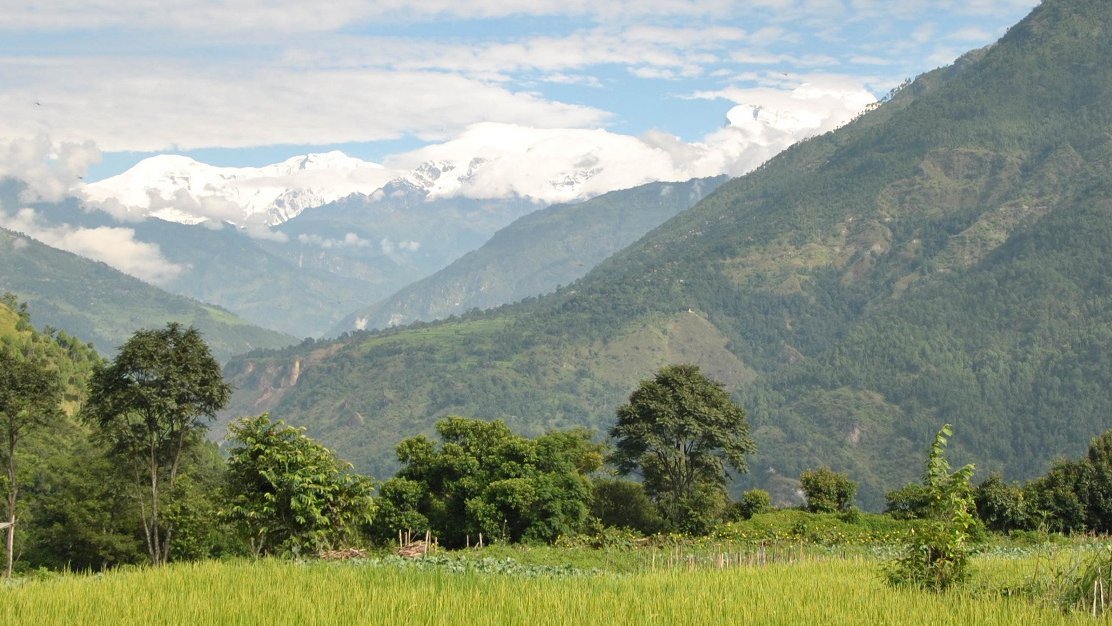
![[Translate to English:] Himalaya Gebirge, Nepal, Forschung zur Gebirgserosion, (Christoff Andermann)](/fileadmin/_processed_/1/b/csm_slider_1_2c9731bd4c.jpg)


The word geomorphology, arising from the Greek words for Earth, form and science, means the study of landforms composing a landscape, of their creation, evolution, and destruction, and of the processes that shape them. The Earth’s surface is the meeting point of the solid earth and the atmosphere and provides the habitat for all life. As such, it is the stage on which a diverse multitude of natural processes interact to shape the environment for all socio-economic activity.
Since the foundation of the Geomorphology section in August 2012, our scientists ask a broad range of questions, spanning scales in time and space from the impact of a pebble on the river bed to the evolution of a whole mountain belt. We follow an interdisciplinary research strategy to address outstanding and emerging challenges in the Earth surface sciences including:
- the role of erosion in the draw down of CO2 into geological storage
- landscape response to climate change
- prediction and early warning of multiple, coupled natural hazards
- and the feedbacks between physical, chemical and biological processes at Earth’s surface
![[Translate to English:] GFZ](/fileadmin/_processed_/c/0/csm_kali_gandaki_2_1b2fddfdb9.webp "[Translate to English:]")
![[Translate to English:] GFZ](/fileadmin/_processed_/7/d/csm_project_banner_6abb73b41b.webp "[Translate to English:]")
![[Translate to English:] GFZ](/fileadmin/_processed_/9/a/csm_STEEPclim_2_bfd58e8fad.webp "[Translate to English:]")
4.6.1 - Organic Surface Geochemistry
Working group lead: Prof. Dr. Dirk Sachse
Working group team: Dr. Cecile Blanchet, M. Sc. Sophia Franziska Dosch (Guest), Dr. Jingjing Guo, M. Sc. Björn Hohmeier, M. Sc. Anna-Sophie Höhne, Dr. Sarwar Nizam (Guest), Dr. Oliver Rach, Chloe Wigmore
Projects of the working group:
- RESET | Roadmaps to Scalable Carbon Dioxide Removal by enhanced Silicate Weathering
- CSponge | Landscapes as Carbon Sponges
- Rain6K | Rainfall variability at the source of the Nile River during the past 6,000 yrs
- WARM-HYDRO | Impact of global warming on regional hydroclimates in the Dead Sea and Lake Van
- CONTINENTAL | Central European Hydroclimate during the Penultimate Interglacial Complex
4.6.2 - Landscape Evolution & Climate Interactions
Working group lead: Prof. Taylor Schildgen
Working group team: Dr. Santiago Leon Vasco, Dr. Fergus McNab (Guest), M. Sc. Andreas Ruby
Projects of the working group:
4.6.3 - Physics of Earth Surface Processes
Working group lead: Dr. Jens Turowski
Working group team: Dr. Christian Marseilles Erikson, Dr. Luc Illien, Stefania Ursica, Dr. Yuezhi Zhong
Projects of the working group:
4.6.4 - Terrestrial Climate Archives
Working group lead: Prof. Dr. Niels Hovius
Working group team: Rostyslav Bleichyk, Prof. Dr. Achim Brauer (Guest), Dr. Emmanuel Guillerm, PD Dr. Ingo Heinrich (Guest), Dr. Gerhard Helle, B. Sc. Anna Karapin-Springorum (Guest), Dr. Rebecca Kearney, Dipl.-Geol. Nicolai Klitscher, Dipl.-Ing. Matthias Köppl, Leon-Elias Latzkow, Mansour Mdawar (Guest), Dr. Jens Mingram, Dipl.-Geogr. Sylvia Pinkerneil, Dr. Birgit Schröder, Dr. Markus Schwab, Dr. Rik Tjallingii, Anais Magalie Sina Urban, Naoual Zaidi
Projects of the working group:
- TephroBridge | Establishing a TEPHROstratigraphy for the Eastern Anatolian Volcanic Provenance
- WARM-HYDRO | Impact of global warming on regional hydroclimates in the Dead Sea and Lake Van
- TERENO Northeast | Environmental Changes and Paleoclimate – A Long-Term Study at Lake Tiefer See
- 8kaDynamics | Climate and Solar Variability during the 8.2 ka BP Event
- CONTINENTAL | Central European Hydroclimate during the Penultimate Interglacial Complex


The role of earthworms in soil organic matter dynamics and persistence
- Speaker: Gerrit Angst (Institute of Soil Biology and Biogeochemistry, Czech Republic)
- Date: 01.07.2026, 1:00pm
- Place: F409 & online
Tracking terrestrial matter from source to sink across Arctic river catchments
- Speaker: Bennet Juhls (Alfred Wegener Institute)
- Date: 24.06.2026, 1:00pm
- Place: F409 & online
Seismic Monitoring of Bedload Transport and Soil Saturation During Flash Floods in the Southwestern United States
- Speaker: Mitchell McLaughlin (New Mexico Institute of Mining and Technology, USA)
- Date: 17.06.2026, 1:00pm
- Place: F409 & online
An overview of all seminars & workshops of the section can be found here
We welcome students and interns with an interest in the Earth and Environmental Sciences and geotechnical engineering. The research areas in our section include geomorphology, environmental seismology, geochemistry, and natural hazards. Your activities could include:
- work in our labs, focusing on biochemistry, sediment and water analysis, or physical processes,
- the analysis of seismic, geochemical or remotely sensed data, or
- the design and construction of scientific equipment in our electronics and construction laboratories.
In the past, we have hosted students and interns for periods ranging from two weeks to six months. Limited financial support may be available, depending on topic, background and length of the internship. To find a good match, it would be helpful if you include a short description of your background, your interests, including specific research groups or projects with which you would like to be involved, and possibly a CV. Before you contact us, our current research themes can support you in identifing your interests.
We offer joint supervision of bachelor and master’s projects together with a professor at your university. You can look through our project and staff pages and approach a suitable scientist with your project idea. If you do not have a project idea, don’t worry! We have many and you can find some of them in the list below. For general inquiries, contact our senior scientists with a brief description of your background and interests, they can put you in touch with suitable scientists in the section:
- Taylor Schildgen: geomorphology & landscape evolution
- Dirk Sachse: biogeochemistry, carbon cycle & climate archives
- Jens Turowski: physical processes at the Earth’s surface & fluvial geomorphology
Potential Bachelor or Master’s Projects:
- How quickly do mountains change shape?
This project focuses on the long-term evolution of landscapes subject to strong gradients in rainfall. Theoretical and laboratory models have shown that strong rainfall on one side of a mountain range will cause it to shift its whole shape over time, leading to a lateral shift in the drainage divide toward the drier side. In this project, we will take advantage of a unique thermochronology dataset that suggests a lateral shift in the drainage divide over time of a range within the Central Andes. By combining landscape evolution modelling with the thermal model Pecube, we will quantify the rate at which the mountain has changed shape, and use newly obtained erosion-rate data from cosmogenic nuclides to test the impact of this shape-shifting on modern erosion patterns.
Contact: Taylor Schildgen - Stochastic modelling of valley evolution
We have recently developed models for the width of fluvial valleys. In the project, a stochastic model for the temporal evolution of valley width would be implemented and explored.
Contact: Jens Turowski - Fluvial bedrock erosion in the lab
Using specifically designed erosion mills, the experiments can be used to investigate sediment and rock property controls on fluvial impact erosion, and to calibrate the mills to natural rivers.
Contact: Jens Turowski - How quickly is in-stream wood destroyed by moving bedload particles?
This question will systematically investigated using laboratory experiments with our abrasion mills.
Contact: Jens Turowski - Do fungal mycelium networks make hillslopes more stable?
Fungi are everywhere in the soil, consisting of networks of strings called mycelium that can span over large areas. These strings need to break when a slope fails, and we want to quantify their breaking strength and effects on soil stability in laboratory experiments.
Contact: Jens Turowski - How does the terrestrial carbon cycle work?
In this project we plan to investigate how surface processes, like erosion and riverine transport, affect the amount and the composition of biospheric carbon (i.e. from soils and modern plants) during their transport from mountain slopes into the ocean. We work on several example river systems in the Himalayas and the Andes. See also project ROCcycle. This project is suited for students interested in geomorphology, sedimentology, organic geochemical analysis and carbon cycle studies.
contact: Dirk Sachse - How fast and why did climate change in the past?
In this project we use organic geochemical tools (biomarkers or organic compounds deposited in in lake sediments and their stable isotope ratios) as recorders climatic changes in the geological past. We reconstruct paleohydrologcial changes and identify drivers of past climate change. We particularly focus on the end of the last Glacial Period and the Holocene, see also project STEEPclim. This project is suited for students interested in organic geochemical analysis and paleoclimate questions.
contact: Dirk Sachse - How regional is ‚global‘ climate change?
In this project we use available high-resolution paleoclimate data (from biomarkers and other proxies) from several climate archives across spatial domains (like Europe) got understands spatial patters of climate change. This project is suitable for a student interested in data analysis, statistics, spatial data analysis and time series analysis and no lab work is required. See also some relevant questions in the STEEPclim project.
contact: Dirk Sachse
All GFZ job offers
Possible doctoral and master's theses as well as all student internships offered at the GFZ can also be found under the link above.