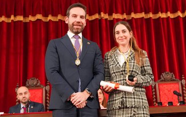
Former Foreign Minister Annalena Baerbock, in her capacity as Potsdam Member of Parliament for the Bündnis 90/Grüne (Green Party) parliamentary group and member of the newly constituted Bundestag Committee on Research, Technology, Aerospace and Technology Assessment, visited the GFZ Helmholtz Centre for Geosciences and DiGOS Potsdam GmbH, a spin-off of the GFZ, on 26 May. She was accompanied by her party colleague Dr Andrea Lübcke, who has been the Brandenburg state chairwoman of Bündnis 90/Grüne since March. Lübcke will succeed Baerbock in both the Bundestag and the Research Committee when Baebock leaves parliament for New York to take up her new position as President of the UN General Assembly in September. During their vistit of the SLR station for satellite distance measurement, the two politicians learned about the GFZ's research in general, topics relevant to the region and satellite research.
You can view impressions of the visit in the picture gallery above.
The visit was prompted by the ongoing renovation work on the Helmert Tower, which Annalena Baerbock had helped to finance as a member of the Bundestag. The 130-year-old building has been undergoing renovation since spring 2024 and is being expanded for renewed scientific use. The federal government is providing around 450,000 euros from its special monument preservation programme and the state of Brandenburg is contributing 533,000 euros.
The Helmert Tower was built in 1892/93 as part of the ‘Observatory for Astronomical and Geodetic Angle Measurements’ on Potsdam's Telegrafenberg and was used for scientific purposes until 1993. The building is named after the geodesist and mathematician Friedrich Robert Helmert, who initiated the construction of the tower as director of the Royal Prussian Geodetic Institute. GFZ researchers from the Geodesy and Geophysics departments are building on Helmert's work and continuing it with modern methods.
Prof. Dr. Susanne Buiter, Scientific Director of the GFZ, once again thanked Annalena Baerbock personally:
“We would like to thank you once again for your support, which is making a significant contribution to the preservation and expansion of the Helmert Tower. The Helmert Tower is not only a historical monument with 130 years of scientific history. After its renovation, its redesigned dome will house the next generation of laser ranging stations for satellite distance measurement, thus also representing the future of Earth measurement and satellite research here at the GFZ.”
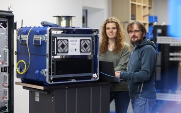
The company DiGOS will be responsible for constructing the fourth generation of the SLR station. Its managing director, André Kloth, was also present during the visit.
The GFZ as an important location factor for the region
During the visit to the current SLR station, Susanne Buiter presented the GFZ to the politicians as the largest non-university research institution in the state and an important location factor for the region – both as an employer and through the above-average number of spin-offs, 14 since 2018 alone. DiGOS is one of the many success stories to emerge from the GFZ start-up scene.
The GFZ is also firmly anchored in the region through its research: for example, through 16 joint appointments with the University of Potsdam, other locations and various research projects, including those related to the energy transition. Here, one focus is on research into the use of the subsurface. For example, the storage of CO2 in geological sandstone layers has been successfully demonstrated in Ketzin, Brandenburg. A demonstration site is still being sought for a similar project on hydrogen storage. Geothermal energy also has great potential in the region as a key to the heat transition. This is demonstrated, among other things, by the activities of the Potsdam energy supplier EWP in the state capital, for which the GFZ is a partner.
Satellite missions as an important basis for geosciences
In the context of the Helmert Tower and SLR station, Buiter also emphasised the importance of satellite data for international geo, environmental and climate research. The GFZ is currently involved in several satellite missions. For example, the GRACE-FO mission, an important collaboration between the GFZ, DLR and NASA, provides unique data on the Earth's gravity field and thus forms the basis for monitoring the global water balance, among other things. The EnMAP environmental satellite has been orbiting the Earth since 2022 and maps its surface in more than 250 colours – providing a basis for statements about the condition of water, vegetation and soil, but also useful for searching for minerals needed for the energy transition. Under the scientific direction of the GFZ, this data – like so much of the data generated by the GFZ – is made available to the international scientific and application community.
More than 50 years of SLR history: the importance of satellite ranging
Satellite Laser Ranging (SLR) has a tradition spanning more than 50 years on Potsdam's Telegrafenberg. The former “Central Institute for Earth Physics” (in GDR) was the first to track a satellite using a laser beam in 1974.
Dr Julian Camilo Rodriguez Villamizar, scientific director of the current SLR station, which has been operating with third-generation technology since 2003, explained how it works and outlined important future prospects.
The principle: satellites are targeted with a laser beam. Special reflectors attached to the satellites reflect the light back to the transmitting stations. The accuracy of the SLR method is essentially determined by the technical parameters of the ground station and the quality of the mirror on the satellite. The Potsdam laser station can measure the distance to satellites in orbits between 400 and 25,000 km above the Earth with an accuracy of about 1 cm and a precision of less than 1 cm. This will be further improved in the fourth generation. The GFZ also makes this data available to the international scientific community.
The GFZ station is part of a global network of SLR stations that enable the orbits of satellites to be determined. Among other things, this is an important prerequisite for evaluating the various data that satellites provide about the Earth.
SLR as a basis for geodetic research
However, SLR is fundamentally essential for geodetic research: it provides data on the position of the Earth in space, on the determination of Earth rotation parameters such as polar motion and day length, on the three-dimensional deformation of the solid Earth, and for a highly accurate global coordinate system. Laser observations are currently also being used to conduct time transfer experiments on the ground and in space via the Atomic Clock Ensemble in Space (ACES) on the International Space Station (ISS). Future cutting-edge technology will enable even more accurate global time determination, e.g. for global satellite navigation systems (GNSS), in particular Galileo. An evaluation of the theory of relativity is also planned.
The new SLR station with fourth-generation technology is now being implemented in collaboration with DiGOS GmbH. It is scheduled to go into operation on the Helmert Tower in 2027.
DiGOS GmbH – Prospects for SLR
DiGOS Managing Director André Kloth presented his company, which has developed into the global market leader in the field of SLR technology since its foundation in 2014. One focus is the development and delivery of turnkey, flexible ‘satellite laser ranging’ stations with a focus on future autonomous stations for satellite laser communication.
Kloth sees important applications for SLR technology – also outside the scientific field – particularly in the area of high-precision observation of space positions: there are now more than 10,000 satellites in near-Earth space, and the number is rising, while space debris is a rapidly growing problem. In this increasingly complex environment, the trajectories of satellites and debris must be measured and anticipated as accurately as possible to avoid collisions.
Importance and security of international data exchange
Given the global networking of GFZ, SLR stations and DiGOS, another important topic of discussion with Baerbock and Lübcke was the international availability and security of scientific data, especially in light of increasing political pressure, particularly in the USA, which is an important partner for many data and long data series.
Further information
Position statement by Susanne Buiter on behalf of the Helmholtz Association on the topic of ‘International availability and security of scientific data’:
About the history of the Helmert Tower
The Helmert Tower was built in 1892/93 together with the Meridian House and the Instrument House as an ‘observatory for astronomical and geodetic angle measurements’. It is named after the geodesist and mathematician Friedrich Robert Helmert, who initiated the construction of the tower as director of the then Royal Prussian Geodetic Institute.
130 years ago, distant targets (known as ‘Miren’) in the Potsdam city area were initially sighted from the roof of the tower, and later even in Berlin and Brandenburg, in order to improve angle measurements. Fixed stars were also observed to obtain highly accurate location and time data.
The Helmert Tower was an important reference point for the Prussian Geodetic Network at the time and became the central point of the Central European grid after the Second World War. Although the tower was located in the GDR, even NATO maps referred to this point. Until the 1990s, researchers from the Central Institute for Earth Physics of the GDR Academy of Sciences used the dome to track satellites using telescopes and laser telescopes. These measurements were discontinued in 1993, and the Helmert Tower fell into disuse.




![[Translate to English:] Susanne Hemmleb (right) and her GEOFON colleague Peter Evans (both Section 2.4) hold the CoreTrus](/fileadmin/_processed_/0/a/csm_cert0677_CoreTrustSeal_Geofon-02_93ac53757f.jpeg)


![[Translate to English:] Group photo with 8 people in a seminar room in front of a screen.](/fileadmin/_processed_/2/1/csm_20251114_News_EU-Water-Resilience-Exchange_Kreibich_c-xx_db4e5be690.jpeg)


![[Translate to English:] Portrait photo, blurry background](/fileadmin/_processed_/a/2/csm_2025_11_06_JEAN_BRAUN_HE_Helmholtz_Portraits-23_2b5c35beee.jpeg)

![[Translate to English:] Excerpt from a map of the Phlegraean Fields near Naples, Italy: Left: Red dots mark smartphone sensors, yellow triangles mark fixed seismological stations. Right: The area is coloured in shades of yellow, red and purple according to the amplification of seismic waves.](/fileadmin/_processed_/3/b/csm_20251028_PM_Smartphone-Earthquake_Slider_12500fa0e6.jpeg)

![[Translate to English:] Green background, portrait of Heidi Kreibich](/fileadmin/_processed_/1/1/csm_20251023_Kreibich-Heidi-2025-Vollformat-green_web_-c-Michael-Bahlo_72946c7fe4.jpeg)

![[Translate to English:] semicircle depicting the future missions, graphics of the new satellites](/fileadmin/_processed_/3/d/csm_2025_10_08_Copernicus_Erweiterung_3f08a76a33.png)
![[Translate to English:] Portrait picture](/fileadmin/_processed_/f/4/csm_Magnall-Joseph-Kachel-c-privat_36e23315c3.jpeg)

