


We develop computer models to simulate the processes responsible for the evolution of the Earth's surface, such as bedrock incision by rivers and glaciers in mountain ranges, or the slow weathering of rock in low relief continental interiors. In doing so, we provide a framework to integrate field observations and laboratory measurements, and make predictions about places where no data exists or concerning the future evolution of the Earth's surface.

![[Translate to English:] Vor und nach dem Wirbelsturm](/fileadmin/_processed_/5/3/csm_Theme2.jpg_65fd32d4c7.webp)


Research groups in our section
Our research group employs a range of researchers who all share a common interest in computer models, but who are from a variety of research backgrounds, including geology, geophysics and mathematics. We also work closely with colleagues in other sections of the GFZ as well as other German and international research institutions and universities.


Projects:
- EROVOL - Impact of extreme climate events on erosion of tropical volcanic islands
- CASCADES - Cascading geohazards on volcanoes
- RELICT - Relief, sediment and tectonics: What is the role of sediment supply and inherited relief in modulating transient adjustment to tectonics?
- Plum-BeatR - Réunion Plume Beat and the Rheology of the mantle

Projects:
- D-TWINS - Digital Twins for Critical Zone under Climate Change
- INITIATE - Climate-tectonics interactions using big data-informed models
- CAUSAL - Causal and mechanism discovery for multiscale and spatio-temporal data in the geosciences
- PCDL-QuaSPA - Physics-Constrained Deep Learning framework for Quantifying Surface Processes across the Arctic region
- MHCC - Mountain Hazards under Climate Change


![[Translate to English:] Berg](/fileadmin/_processed_/8/3/csm_IMG_3179_f0d630e011.webp "[Translate to English:]")


German-French workshop on volcanic islands, 11–12 May, at the GFZ
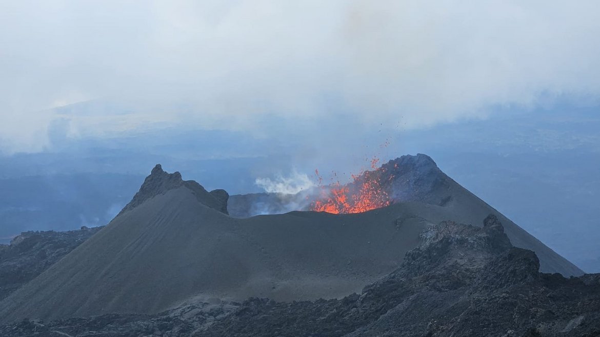
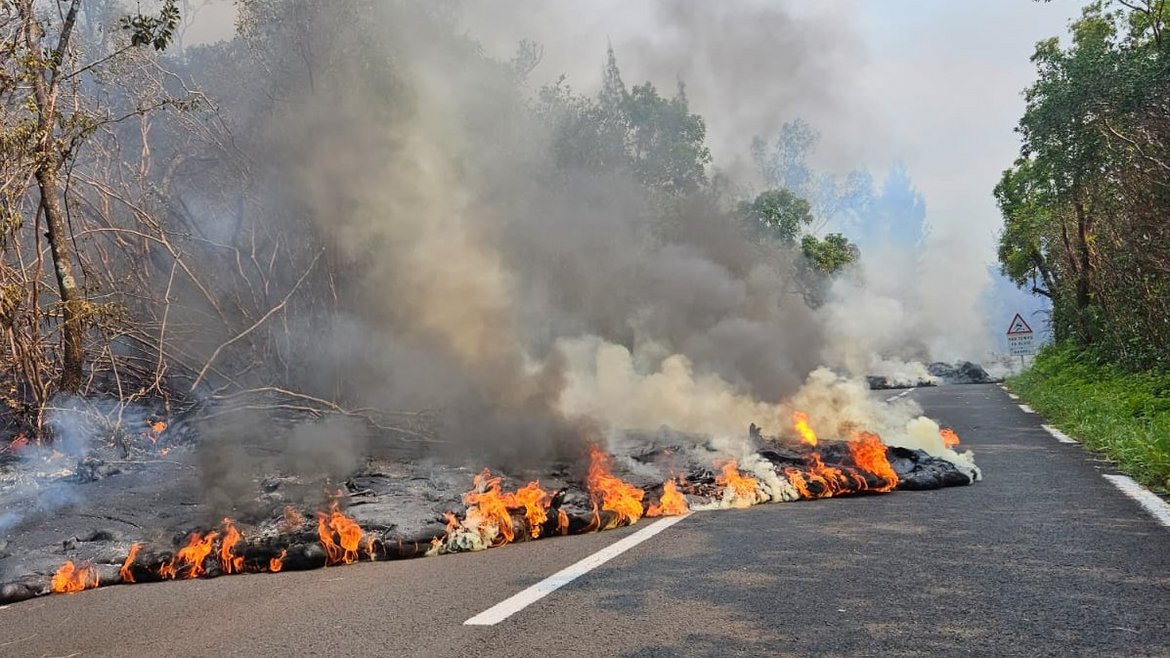
Join us for an exceptional German-French workshop on volcanic islands on 11–12 May at the GFZ.
This interdisciplinary, two-day workshop brings together early career researchers to explore key aspects of tropical volcanic island systems. Topics include volcanic processes and dynamics, natural hazards, biodiversity and landscape evolution, geochemistry, climate interactions and human impacts. The workshop features thematic sessions, discussions and networking opportunities and is supported by the Franco-German University. It will take place at GFZ.
Please use this link to register for the workshop:
https://doodle.com/sign-up-sheet/participate/f8e2b9f5-af39-410f-9ecc-1be580a0b98c/select
Location: GFZ Helmholtz Centre for Geosciences, Lecture rooms 1-2, Building H, Telegrafenberg, 14473 Potsdam
You can find the the detailed programme here:
Day 1 (Monday, May 11th)
9:15-9:30 Welcome and introduction
9:30 Session 1: Volcanic processes and dynamics
Lunch 12:30-13:30
13:30 Session 2: Natural hazards
Break
15:30 Session 3: Biodiversity and landscape evolution
Discussion and diner at MOIM in Berlin
Day 2 (Tuesday, May 12th)
9:00 Session 4: Hotspot volcanoes and mantle plumes: advances and open questions
Break
11:00 Session 5: New geochemistry tools for tropical volcanic settings
12:30-13:30 Lunch
13:30 Session 6: Climate, erosion, and volcaniclastic sedimentation
Break
15:30 Session 7: Retroactive effects of human populations on volcanic Islands
Discussion: funding opportunities for German-French collaborations
17:30 Guided tour of the Refractor (historical telescope, building A27, Telegrafenberg, 14473 Potsdam, ~20 minutes)
Contact: Dr. Loraine Gourbet
Section 4.7 Seminars

Seminars/Talks:
Our section regularly hosts seminars and talks by speakers from all over the world.
Please also check out Landscapes Live, a weekly online seminar series freely accessible to the international scientific community interested in various aspects of geomorphology. Recent talk can be viewed on the YouTube channel.
List of past seminars
25.2.2025 - Joanmarie Del Vecchio, College of William and Mary, USA. Erosion and Drainage Patterns in Permafrost Landscapes: Insights and Implications
31.1.2025 - Nicole Richter, RWTH Aachen University. A tale of Penguins and Volcanoes
30.1.2025 - Paola Passalacqua, University of Texas at Austin, The Complex Dynamics of Low Gradient Landscapes under Change
30.1.2025 - Laure Guerit, CNRS/University of Rennes, Use of Terrestrial Lidar to Characterize the Spatio-temporal Variability of Fluvial Sediments
12.12.2024 - Cécile Gautheron, Université Grenoble-Alpes, Recording Cenozoic climatic and geodynamic changes impacting anorogenic domains using supergene minerals in laterite
12.12.2024 - Vivi K Pedersen, Aarhus University, Links between geomorphology and sea level
10.12.2024 - Robert Hadfield, University of Cologne, Playing Evolutionary 'Frogger': Diversification of Hawaiian Damselflies Across Sequential Volcanic Islands
26.11.2024 - Pietro Sternai, University of Milano-Bicocca, Inversion of paleoclimate timeseries to constrain source and sink fluxes of surface CO2
22.10.2024 - Richard Ott, University of Amsterdam, Erosion through time and space in the Northern Andes
23.9.2024 - Christian Klassert, UFZ, Coupling hydrological and economic models to understand agricultural drought impacts and adaptation
25.6.2024 - Yaquan Chang, ETH Zürich, Geologic controls on plant biodiversity of the Hengduan Mountains
5.5.2024 - Marin Clark, University of Michigan, Leveraging land surface hazards as an observatory: from societal impact to mountain belt evolution
7.5.2024 - Lydian Boschman, Utrecht University, The co-evolution of Earth and life in biodiversity hotspots: unraveling the imprint of geological history on species diversification
9.4.2024 - Anne Replumaz, CNRS, University Grenoble Alpes, Building the Tibetan orogenic plateau: the role of thrust faults and the influence of erosion on the eastern edge.
12.3.2024 - Benjamin Campforts, Vrije Universiteit Amsterdam, Which came first: mountain or landslide?
20.2.2024 - Alexander Neely, University Tübingen, Safe storage of radioactive waste, underneath rivers that move
21.11.2023 - Malgorzata Chmiel, CNRS, Observatoire Côte d’Azur, How can seismology provide a better understanding of mountain hazards?
14.11.2023 - Susannah Morey, University of Colorado Boulder, The erosional and depositional potential of megafloods in the eastern Himalaya: insights from 2D hydraulic simulations
17.10.2023 - Celia A Baumhoer, DLR, The Potential of Earth Observation for Monitoring Land Surface Dynamics in Polar and Cold Regions
10.10.2023 - Zuzanna Swirad, Polish Academy of Sciences, Coastal cliff erosion monitoring across spatio-temporal scales
12.9.2023 - Sean F Gallen, Colorado State University, Slab-mantle interactions pace forearc rock uplift during subduction retreat, an example from Calabria, Italy
14.3.2023 - Russell Pysklywec, University of Toronto, The puzzling tectonic damage of drifting microcontinents: Explained by a subduction pulley?
6.3.2023 - Eric Deal, ETH Zürich, Physical models of width in channelized flows
10.8.2022 - Gregory Ruetenik, Czech Academy of Sciences, The influence of surface processes on sea level
28.6.2022 - Katrina Gelwick, ETH Zürich, Quantifying landscape transience on the Southeast Tibetan Plateau
14.6.2022 - Alba M. Rodríguez Padilla, UC Davies, The geologic fingerprint of multi-fault earthquakes in southern California
31.5.2022 - Rachel Havranek, Colorado University Boulder, Development of the soil water isotope storage system: building a new way to understand paleoclimate proxies.
9.5.2022 - Kai Deng, ETH Zürich, The rise and fall of the Taiwan orogen: a story told by U-Pb-Sr-Nd-Be isotopes
Internships for students
Researchers in Section 4.7 can offer projects to interns (towards the end of Bachelor studies) and/or Master students. We specialise in the development and use of sophisticated numerical models to study the evolution of the Earth’s surface under the combined action of tectonic forces and climate. We welcome interns and Master students from the Earth Sciences, Applied Mathematics, Physics or Biology who would be interested in gaining experience in computer modeling of surface processes.
Potential projects include:
- Investigation of the effect of precipitation variability (in space and time) on landscape evolution
- Studying links between landscape and life evolution
- Development of highly efficient algorithms to solve landscape evolution equations
- Inverting landscape morphology to constrain tectonic activity and/or climate of the past
- Inverting the sedimentary record
- Studying the links between model parameters and morphometry
- etc.
Do not hesitate to look at all the ongoing research projects on our website and/or contact us via our secretariat if you are interested. If you are sending us a cover letter and/or CV, please make sure these are in English.
Internship opportunity for students
When Geomorphology Meets Quantum Physics: a QSVM Model for Surface Flows Classification
Landslides, debris flow, hyperconcentrated flow, and floods are among the most dangerous natural hazards worldwide. One of the fundamental tasks for geomorphologists is to classify and identify which kinds of processes they observe in the field. The task is more challenging than it sounds, especially considering high-damage processes like debris flows and landslides. Meanwhile, multiple dimensionless numbers (e.g., Reynolds number and Einstein number) based on first-principle physics have been widely used to describe these natural flows. When we use these dimensionless numbers and datasets to classify the flow, we automatically face a long-standing challenge in machine learning (maybe one of the biggest challenges in data science): the curse of dimensionality. One of the expertise for quantum machine learning methods (e.g., QSVM) is to deal with such a high-dimensional dataset. Therefore, we ask the central research question in geomorphology and machine learning: can we objectively define the type of natural flows using the dimensionless number and Quantum machine learning methods?
The applicant will work on a high-dimensional dataset for different surface flows. They are usually dimensionless in a physical sense based on the theoretical derivation and well-defined with uncertainties. Please see the following reference for details: Du, J., Zhou, G. G., Tang, H., Turowski, J. M., & Cui, K. F. E. (2023). Classification of Stream, Hyperconcentrated, and Debris Flow Using Dimensional Analysis and Machine Learning. Water Resources Research, 59, e2022WR033242. https://doi.org/10.1029/2022W
The applicant will develop a high-dimensional quantum support vector machine model (e.g., QSVM) to classify the type of natural flow in the dataset. Based on our previous study, the applicant needs to design a simple, supervised quantum machine learning algorithm. If time allows, we will investigate the possibility of designing and training an unsupervised quantum machine learning algorithm such as the Quantum K-means model. For more information, applicants can check the following papers:
Rebentrost, P., Mohseni, M., & Lloyd, S. (2014). Quantum support vector machine for big data classification. Physical review letters, 113(13), 130503.
Wu, Z., Song, T., & Zhang, Y. (2022). Quantum k-means algorithm based on Manhattan distance. Quantum Information Processing, 21(1), 19.
Researcher in charge. Dr. Hui Tang