What we know so far
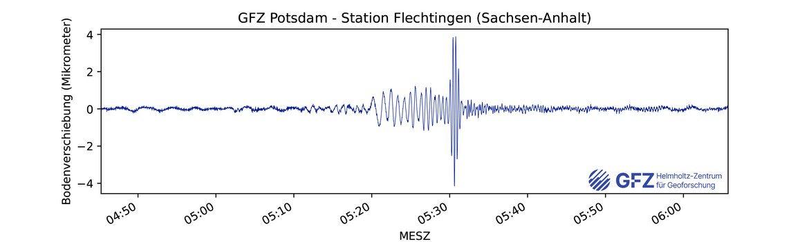
On 26 August 2026, seismometers worldwide registered a moderate “earthquake” in the border region between Tibet and Nepal. The magnitude was estimated at 5.2 to 5.7 Mw. It was timed at 02:52:23 Universal Time (UTC), that is 8:37am in Nepal, and 10:52am China Standard Time (the Central European Summer Time CEST was 4:52:32am). The surface waves of the earthquake, most probably caused be a gigantic mass movement, reached Germany roughly 40 minutes later in the early morning hours and were recorded by GEOFON stations of GFZ (Flechtingen, Saxony-Anhalt).
The mechanism of the mass movement was most probably the break-off of a hanging glacier and underlying bedrock in the north flank of the Langtang Massif in the Himalya mountains between Nepal and Tibet.
The rock and ice masses slid down a steep slope, likely generating large amounts of heat, which led to a nearly instantaneous melting of massive volumes of ice. Together with boulders, rubble and sediment from the stream bed and valley shoulders, a huge and devastating mud flow formed, gushing downstream the river Lende Khola. The wall of water reached heights of several tens of metres and a velocity between 40 to 50 metres per second, i.e., more than 130 kph.
Less than ten minutes after the event, the first wave hit the Chinese-Nepalese border station Gyirong with devastating force. Surveillance cameras recorded the event in drastic detail. Time stamps show 10:59am local time. All infrastructure at the border was obliterated and a massive debris fill now occupies the site.
The mudflow travelled further downstream leaving behind a zone of destruction that expanded to more than 100 kilometres in the valley of river Trishuli, and caused a river level rise of more than 10 metres at the confluence with the Seti Gandaki River. Farther downstream the flood was recorded beyond the Himalayan mountain front.
Could such an event have been prevented?
Prof. Dr. Niels Hovius, head of GFZ’s section Geomorphology, has been working in the region for more than a decade. He says: “There is no way to prevent such events. They are natural events, occurring several times per year in the Himalayas. However, early warning systems based on seismic signals are possible. Such a system could have issued warnings downstream with only a few minutes delay. This could give people minutes to tens of minutes to reach safe ground.”
Early warning systems in high-mountain regions: General challenges
Currently, flash flood early warning is sparse, and is based on monitoring of individual lakes or channels, for example with water stage sensors. This approach relies on the accurate identification of dangerous lakes, and requires elaborate and costly instrumentation. It quickly becomes unfeasible as lake numbers and volumes grow, and does not account for the important number of floods that don’t involve the purging of a pre-existing glacier lake.
Almost all of the catastrophic events of recent years in the Himalaya have originated from sources not designated as dangerous, highlighting the risks of relying on monitoring of potential flood sources. As many Himalayan rivers cross national borders, traditional warning systems often need to rely on seamless international communication and cooperation both of which have proven difficult due, amongst others, to restrictions in the dissemination of discharge information.
Finally, existing systems require instruments to be placed on lake margins or river banks, where they are easily destroyed during flood events. This hampers assessment of the severity of floods, which is critical to anticipating their downstream propagation.
A system of remote real-time flood detection and location would solve these problems, allowing for regional monitoring without the need to instrument individual lakes or rivers, detecting transboundary floods before they arrive at national borders, and identifying large flash floods regardless of their source or trigger.
A seismic-based approach
A team of scientists and engineers at the GFZ and Universität Potsdam, ISTerre and IGE Grenoble, in partnership with the Nepal Department of Hrdrology and Meteorology, and the Nepal Department of Mines and Geology, aims to develop and test an alternative paradigm of regional flood detection and early warning that meets these goals. It makes use of the seismic signals emitted by powerful geomorphic processes at the Earth’s surface.
The resulting seismic signals, caused by the passage of glacial lake outburst floods (GLOFs) and other catastrophic floods, can be detected remotely, even at large distances from the flood source. This raises the prospect of a distributed early warning system, based around networks of seismometers that could simultaneously monitor all flood sources over large regions with no need for prior knowledge of potential event locations or triggers. That this is feasible is underlined by studies of extreme events in the last five years.
GFZ scientists, together with colleagues, have been investigating several flash floods since 2021. Their results showed that, with the already existing seismic network, early warning for an event on February 7, 2021 would have been possible – had a system existed to detect and trigger an alert in real time, with up to 11 minutes of potential early warning for the locality where most fatalities occurred (a hydropower site under construction).
(Cook, K. L., Rekapalli, R., Dietze, M., Pilz, M., Cesca, S., Rao, N. P., ... & Hovius, N. (2021). Detection and potential early warning of catastrophic flow events with regional seismic networks. Science, 374(6563), 87-92; https://doi.org/10.1126/science.abj1227)
Seismometer-based warning system: Specific challenges
It is one thing to use existing seismic records to demonstrate that it is possible to detect and locate extreme mountain floods after the fact. It is an altogether different thing to do this in real time for the purpose of early warning. A number of scientific and technical challenges will need to be addressed.
First, an instrument network will need to be specified for the purpose of Earth surface process monitoring. Existing seismometer networks are typically optimized for solid Earth challenges. Their instruments may be exposed to higher levels of background noise, and spaced at distances greater than those required for reliable and precise detection and location of surface sources.
Second, the network stations must be autonomous and telemetered. The GFZ has a strong tradition in the development and deployment of set ups with these characteristics. In remote mountain settings, it will be necessary to tap into the growing satellite-based communications capability, which will also reduce the risk of data stream interruption due to earthquake damage to GSM infrastructure.
Third, identification of extreme mountain floods and other hazardous surface processes will have to be automated. This requires a library of historical examples for training purposes. It also requires algorithms that are sufficiently flexible, so that they can reliably deal with the unique attributes of individual events. Here, GFZ has been leading in developing AI-based approaches.
This is also true for the fourth challenge, rapid location and tracking of ongoing flood events. Although classic seismological approaches have yielded flood locations that match ground observations encouragingly well, they struggle to deal with the complexity of signals from surface sources. Alternative search strategies may have to be developed to optimize our ability to determine and update the location of flood fronts and subsequent waves of mobile water and sediment.
Fifth and finally, warnings have to be issued in ways that effectively reach and activate stakeholders, including local populations, authorities and operators of hydropower installations. This so-called last mile challenge is universal in early warning, but always requires local leadership, tuned to cultural, political and technical specificities.
[edit; 28.08.2026, 13:00]
Digital Twin for early warning
GFZ is developing a Digital Twin approach for early warning of high-mountain floods and mass movements. It combines real-time seismic monitoring with weather, river and satellite observations, automated event detection and characterisation, and rapid physics- and data-driven modelling. The aim is to assess as early as possible how an event may evolve and which downstream areas could potentially be affected.
The approach builds on the D-TWINS project, funded by the Helmholtz Association, and on work by Hui Tang, Jens Turowski and Qi Zhou on seismic monitoring and modelling of debris flows and cryospheric hazards. Several key components already exist as research prototypes. The next step is to integrate them into an end-to-end demonstrator and test it through a Himalayan pilot. This will require reliable telemetry, local calibration, automated analysis, and warning protocols developed in collaboration with the relevant authorities.
Cui, Y., Y. Li, H. Tang, J.M. Turowski, Y. Yan, N. A. Bazai, R. Wei, L. Li, 2024, A digital-twin platform for cryospheric disaster warning, National Science Reviews, 11, nwae300, https://doi.org/10.1093/nsr/nwae300
[/edit]
Further reading (English translation of a German article on Early Warning Systems in the Himalay region)
“GLOF Early Warning Using Seismometer Networks” (PDF)
[https://media.gfz.de/gfz/wv/pm/26/20260827_GLOF-Early-Warning-1.pdf]


![[Translate to English:] Veranschaulichung der Veranstaltung.](/fileadmin/_processed_/c/5/csm_20260928_Kachel_37c583cb50.webp)


![[Translate to English:] Alle Länder Afrikas gelistet mit relativem Malariarisiko](/fileadmin/_processed_/1/b/csm_2026-08-20-L%C3%A4nderliste_Malariarisiko_web_d547ebb81d.webp "[Translate to English:]")


![[Translate to English:] Bewaldetes Gebiet mit historischen Gebäuden](/fileadmin/_processed_/5/e/csm_Telegrafenberg-2021_300dpi_Marcel-Ludwig-GFZ_web_70a5c15a88.webp "[Translate to English:]")


![[Translate to English:] Karte](/fileadmin/_processed_/4/8/csm_20260625-0945b_Venezuela_Nachbeben_-c-EarthquakeExplorer-GFZ_04f208410a.webp)

