![[Translate to English:] Alle Länder Afrikas gelistet mit relativem Malariarisiko](/fileadmin/_processed_/1/b/csm_2026-08-20-L%C3%A4nderliste_Malariarisiko_web_01b584d29e.png "[Translate to English:]")
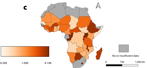
Mosquitoes are deadly animals. They transmit numerous diseases that kill up to one million people each year. Malaria claims the largest number of victims, with more than half a million deaths annually. The risk is particularly high in areas with large populations of malaria-parasite carrying mosquitoes. Stagnant water provides ideal conditions for the insects—and floods, in particular, create these habitats: standing floodwaters and, especially, receding floodwaters leave behind pools, puddles, and isolated bodies of surface water that serve as breeding grounds for Anopheles mosquitoes. These mosquitoes are hosts for the Plasmodium falciparum parasite, which causes malaria.
It therefore stands to reason that areas at risk of flooding in the tropics and subtropics also increase the risk of malaria. However, estimates of the risk in flood-prone areas have been limited to date due to insufficient large-scale geodata. Now, a new study by researchers led by Jeremy Eudaric of the Technical University of Munich, along with Dr. Nivedita Sairam and Prof. Heidi Kreibich of the GFZ Helmholtz Centre for Geosciences, shows that in East and West Africa, the risk of malaria is elevated in flood-prone regions compared to national reference values.
In their study, the research team led by Jeremy Eudaric integrated high-resolution flood maps (2000–2018) from the Global Flood Database, malaria incidence data from the Malaria Atlas Project, and population data across 492 flood-prone zones in 38 sub-Saharan African countries. The researchers used statistical spatial models to assess the relative risk of malaria and its influencing factors. The relative risk describes the difference between the general risk of malaria and the risk that arises following a flood event.
The researchers estimate that 12 million people diagnosed with Plasmodium falciparum were exposed to flooding events, which corresponds to one-third of the total population affected by flooding. The results highlight, in particular, key regions with an elevated relative risk of malaria. Distinct regional patterns emerged. Looking more closely at individual countries, Uganda has the highest number of infections with the malaria pathogen. Uganda should therefore be given special attention following flood events.
The maps showing key regions can help identify where flooding is associated with a higher malaria burden. The study informs policy makers about the geographic distribution of vulnerable zones that have been particularly affected in the past, thereby supporting malaria control strategies.
In their outlook, the researchers write that their approach could also help identify future risks. Additional socioeconomic factors such as per capita income, poverty levels, and meteorological and environmental factors such as temperature and vegetation data could further refine the analyses.
Further information:
Eudaric, J., de Ruiter, M. C., Sairam, N., Camero, A., Shahi, K. R., Smith, M. W., Zhu, X. X., Kreibich, H. (2026): Geospatial mapping of malaria risk in flood-prone zones of Sub-Saharan Africa.
- Scientific Reports, 16, 18002. https://doi.org/10.1038/s41598-026-54811-7


![[Translate to English:] Veranschaulichung der Veranstaltung.](/fileadmin/_processed_/c/5/csm_20260928_Kachel_37c583cb50.webp)


![[Translate to English:] Bewaldetes Gebiet mit historischen Gebäuden](/fileadmin/_processed_/5/e/csm_Telegrafenberg-2021_300dpi_Marcel-Ludwig-GFZ_web_70a5c15a88.webp "[Translate to English:]")


![[Translate to English:] Karte](/fileadmin/_processed_/4/8/csm_20260625-0945b_Venezuela_Nachbeben_-c-EarthquakeExplorer-GFZ_04f208410a.webp)


