Earthquakes are among the most devastating natural disasters: together with their direct consequences, such as tsunamis and landslides, they are responsible for 58% of fatalities worldwide and for 21% of economic losses caused by natural disasters.1,2 The United Nations General Assembly has designated 29 April of each year – starting in 2026 – as the International Day in Memory of the Victims of Earthquakes. This is intended to highlight both the need to support earthquake victims and the importance of building resilience to earthquakes.
At the GFZ Helmholtz Centre for Geosciences in Potsdam, research into the causes, precursor phenomena and possibilities for predicting earthquakes, as well as the assessment of risk for regions around the world, is a key focus area in which scientists across various sections are conducting research.
One outcome of this research is a wide range of information resources aimed not only at the international scientific community and public authorities but also at people living in or travelling to earthquake-prone regions.
To mark the first-ever World Day of Remembrance for Earthquake Victims, we have compiled the most important GFZ information resources here:
The overview page “Earthquake Information” provides background information on earthquakes and access to various data portals that supply up-to-date data, some of which are listed individually below.
For experts (and interested members of the public)
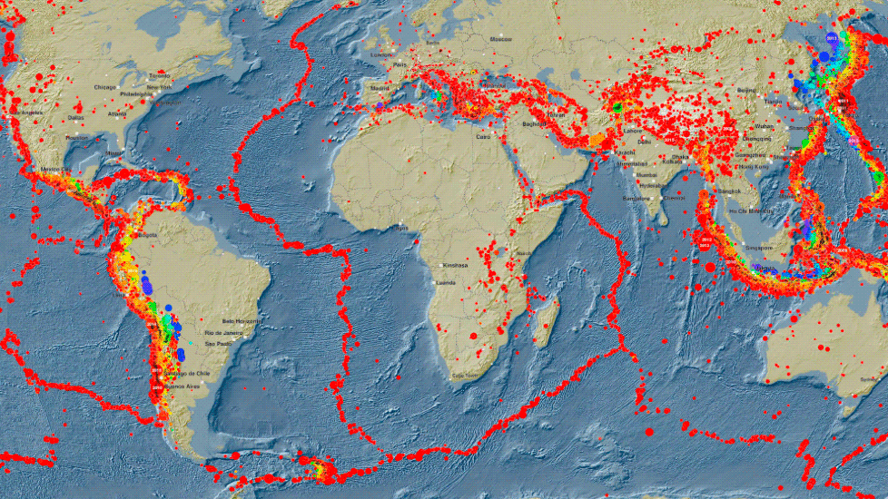
Using the interactive map, the GFZ makes current and historical earthquake data available for further use, exploration and analysis, based on the global GEOFON monitoring network. This data comes from more than 80 of its own stations and a further 1,000 stations operated by other services worldwide. A video tutorial helps those using the portal for the first time.
Hazard Maps
Seismologists develop seismic hazard maps for many regions worldwide or contribute to them through their work. This allows the probability of strong ground shaking caused by earthquakes to be specified for a defined period. The maps are primarily intended for experts.
Map of Germany: Earthquake activity and seismic hazard
Earthquake risk in Europe (in English only)
Together with international partners, GFZ researchers published an updated “World Stress Map” in 2025. This map shows stresses in the Earth’s crust and is important for understanding plate tectonics and earthquake cycles, as well as for the safe use of the subsurface, for example in geothermal energy or the storage of radioactive waste. The update contains more than twice as much data as the 2016 version, including analyses from over 3,000 deep boreholes. Overall, the database has grown from 7,300 entries in 1992 to over 100,000. The data and maps are freely accessible, as is an online tool for creating your own stress maps.
For interested members of the public and school classes
The World Map of Earthquake Activity provides an overview of earthquakes from 2008 to 2023. It can be printed out as a poster.
Teaching materials for pupils can be found in the ‘Working Materials’ section further down the ‘Current Earthquake Information’ website.
For travellers
Information sheet: What to do during an earthquake
The information sheet was revised by the GFZ last year in cooperation with the Federal Office for Civil Protection and Disaster Assistance. It provides guidance for people travelling to or living in earthquake-prone areas on how to prepare adequately, what to do during an earthquake and afterwards.
Background: What makes earthquakes so dangerous?
There are various factors that contribute to the high number of casualties and damage caused by earthquakes worldwide. A key point to remember is: it is not the earthquakes that kills people, but the buildings. Inadequate structural stability or a lack of building standards are therefore a major factor. Furthermore, it is still not possible to predict earthquakes. Crucial for providing assistance after an earthquake are the rapid alerting of emergency services and information that is as precise as possible regarding the location and magnitude of the quake. The consequences of an earthquake can lead to further casualties, for example through tsunamis, aftershocks or subsequent landslides.
Contributions from GFZ research to reducing the potential risk to people from earthquakes
Topic: Earthquake prediction – ‘The Holy Grail’
“Predicting the time, magnitude and location of earthquakes is the Holy Grail of seismology, but it is not possible with the current state of research. Such a predictive capability would be a breakthrough that could save millions of lives,” says Prof. Marco Bohnhoff, Head of GFZ Section 4.2 Geomechanics and Scientific Drilling. “We assume that earthquakes are generally preceded by forerunner processes. However, these processes are difficult to measure in nature, as we cannot get close enough to the site of the event, which lies several kilometres underground.”
Therefore, the researchers use experiments in the high-pressure laboratory to analyse earthquakes and the associated fracture processes on a small scale under controlled conditions. Patterns observed in the laboratory can help to identify similar phenomena in the field and thus detect them early enough for warning systems to be activated. To this end, the scientists also search for preceding patterns and precursor phenomena in the aftermath of natural earthquakes. Initial results on this are available following the catastrophic series of earthquakes in Türkiye and Syria in 2023.
Topic: Improved building safety
The GFZ is involved in German and European committees where standards for earthquake-resistant construction are developed.
Conversely, building data is incorporated into risk analysis, which is further developed on the basis of seismic hazard maps. The aim is to use numerical models to predict the extent of damage to each building type during strong tremors (fragility) and the corresponding impacts in the form of economic or human losses (vulnerability).
Topic: Effective civil protection
When severe earthquakes occur, local civil protection and disaster management authorities need information on the location and extent of the disaster as quickly and comprehensively as possible. Here, the GFZ provides relevant data automatically within a few minutes via the global service GEOFON.
Another approach is the use of smartphone data to immediately assess the situation of people on the ground.
Topic: Earthquake hazard in Germany
Although the earthquake hazard in Germany is relatively low by global standards, it is by no means negligible. Minor earthquakes occur time and again, particularly in the Rhine region, the Swabian Alb, as well as in eastern Thuringia and western Saxony, including the Vogtland swarm earthquake zone. However, earthquakes that are clearly felt or even cause damage are rare occurrences in Germany.
Map of Germany showing seismic activity and earthquake hazard
Earthquake risk in Europe (in English only)
New episode of the podcast “Forschungsquartett” by detector.fm on the topic of earthquake research at the GFZ (from 29 April 2026, in German only)
Seismologist Dr Annabel Händel from GFZ Section 2.6 “Seismic Hazard and Risk Dynamics” discusses the origins of earthquakes using the Istanbul region as an example, earthquake hazard in Germany, and new technologies for detecting and monitoring earthquakes. For example, the large-scale project SAFAtor, which she manages, is investigating the use of fibre-optic telephone cables as sensors.
1 EM-DAT – The International Disaster Database, www.emdat.be
2 https://www.munichre.com/de/risiken/naturkatastrophen/erdbeben.html
Further information on earthquake research at the GFZ, as well as contact details for individual researchers, can be found on the overview page “Current Earthquake Information” and on the section pages linked there.


![[Translate to English:] Karte](/fileadmin/_processed_/4/8/csm_20260625-0945b_Venezuela_Nachbeben_-c-EarthquakeExplorer-GFZ_04f208410a.webp)


![[Translate to English:] Gruppenbild](/fileadmin/_processed_/9/e/csm_20260508_Olympiade-der-Geowissenschaften_-c-Manuela-Lange-GFZ_GFZ-ID-800_be464de576.webp "[Translate to English:]")


